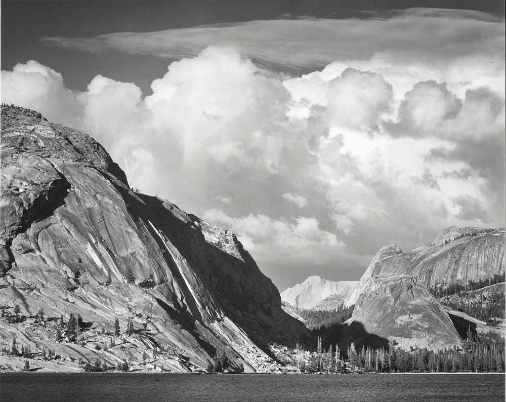
Tenaya Lake, Mount Conness, Yosemite National Park, by Ansel Adams.
My dad’s younger brothers were favored uncles; they were grown-ups, yes, but they were fun. Bob, the youngest, was only a half-generation away from me. After spending a year in Viet Nam with the Navy, Bob had returned to Alameda California in 1972 to complete his service. He arranged for my brother Eric and me to spend time visiting him there during our spring break. The week with him was quite an adventure for us teenagers. It left a strong impression of California culture and provided an intimate look into the life of a highly regarded adult. We met the wonderful woman who would become our Aunt Karen. They planned to wed in June later that year.
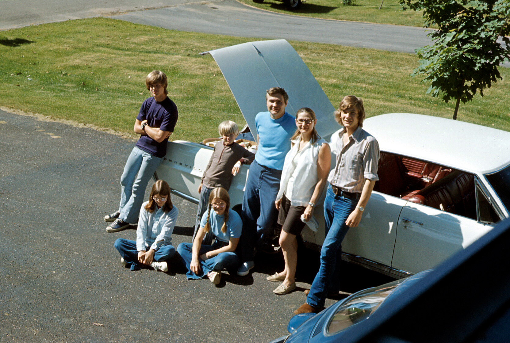
Their wedding became a focus for the summer, and my dad arranged a complex family summer vacation to attend this event. We numbered seven, and were no longer small enough to all fit into our Volkswagen bug as we once had. Nor could we fit in the large Pontiac Bonneville, later known as the Great White Whale, especially since we were bringing camping gear for Dad’s planned post-wedding vacation activity: backpacking through Yosemite Park. So both vehicles were recruited for the cause. We had four licensed drivers in our clan and could tag-team the drive to California and back.
I described this backpacking adventure in a previous post. After that memorable experience, we continued by exploring Yosemite Valley. In addition to the famous views of Half Dome and El Capitan, there were art galleries! Yosemite was the adopted home of a number of artists, including photographer Ansel Adams, who had a studio and school here. Many of his images were on display and available for sale.
In 1972 our family went on a road trip to California. It was to attend my uncle’s wedding. Having just completed his service as a medical officer in the Navy, he was marrying a California girl from a well-known family. I had to look up the word debutante.
The wedding served as an excuse for my dad to extend our travel to California for his brother’s wedding, by adding on a backpacking trip to one of the premier wilderness areas in the world—Yosemite National Park. He had become fascinated with hiking backcountry trails ever since some backpackers emerged from the forested slopes of Glacier Park into a clearing —a roadside stop where our family was, at that moment, enjoying the amazing view. We noticed them from within our rented Dodge “motor home”, an early incarnation of what today is the ubiquitous recreational vehicle. As we watched the hikers organize themselves for the next leg of their backcountry journey, I remember Dad’s respect and curiosity about them. Clearly, the backpackers made a strong impression.
In the following years, Dad took each of his kids in turn on a backpacking trip to teach, and to learn further for himself, the techniques and pleasures of hiking in remote, beautiful settings with nothing more than what you carry on your back.
And now he was ready to go on a backpacking trip with the entire family. This time he needed to be more nimble and have more flexibility than a giant RV could offer. And now that more family members were licensed to drive, we would take both of the family cars: a high-capacity Pontiac Bonneville, later referred to as “the White Whale”, and the compact, but near-indestructible Volkswagen Beetle, which had survived numerous stick shift training sessions of young drivers.
I think this is a picture of us in front of the Bonneville, with the Bug showing slightly in the foreground, perhaps as they are being loaded. The fashion styles of the day are clearly displayed.
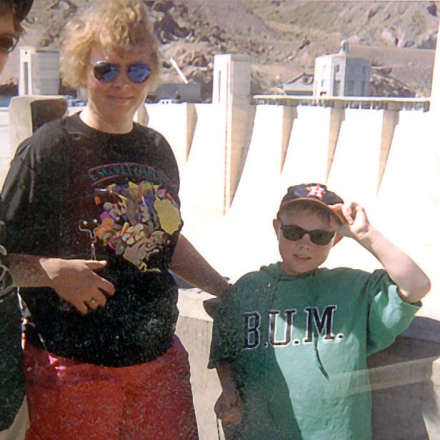
We were at the beginning of a summer camping trip to visit the Grand Canyon. Our son Derek, age 9, was excited. We had flown to Las Vegas, rented a car, and were preparing to leave our overnight hotel room to drive to Grand Canyon National Park.
I informed him that we would first be visiting the Hoover Dam, the famous structure that generates electrical power and created Lake Mead. This was distressing news to Derek. He was eager to get to the Grand Canyon and didn’t want to be delayed by some side trip his dad had dreamed up. He’d waited long enough. He objected, he complained, he sulked, he argued, he refused to cooperate. When we told him that he needed to get his stuff together, he cursed, using the strongest language he knew at the time: “ I DON’T WANTTO GO TO THE SUCKY HOOVER DAM!”
Of course, one can’t get to the Grand Canyon from Las Vegas, without going over the dam, so after finally checking out of the hotel, and a short drive later, we were on the winding mountain road approaching it. By the time we stopped at the huge concrete wall spanning the Black Canyon of the Colorado River, Derek had evidently changed his mind.
We joined a tour group that took us down an elevator from one of the road-level art-deco turrets to a long curving hallway where we learned about the dam’s structure and history. Derek was awestruck at being deep inside this immense man-made object. He felt the vibrations from the massive electric generators as we looked from an observation deck. He would have explored further, but the tour ended, and I reminded him we needed to get back on the road to reach the Grand Canyon before nighttime.
I’m not sure if any lessons were learned that day, but it was a day that I can’t think back on without smiling.
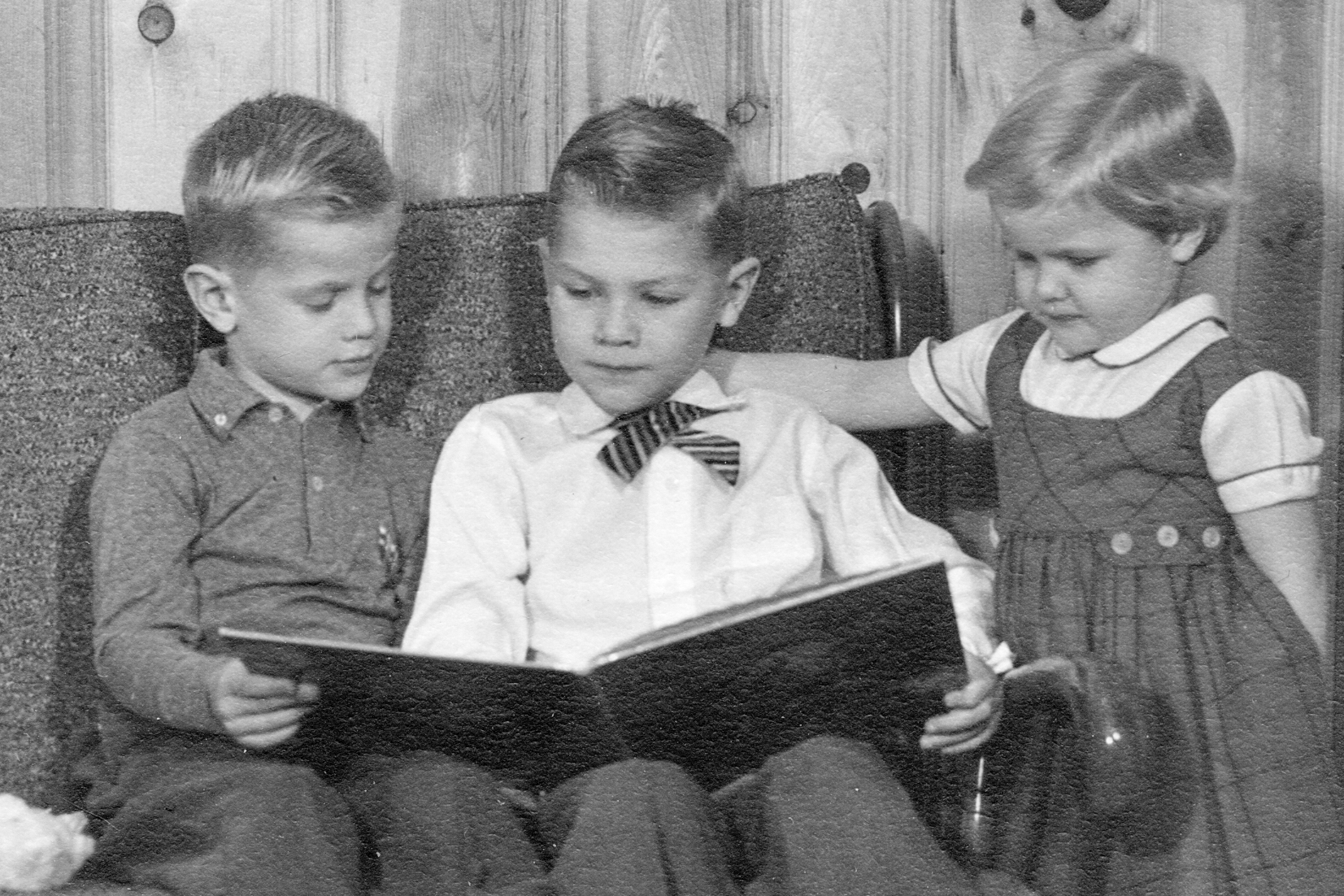
Brother Eric and I read a book to our sister Laurie..
A child’s vocabulary expands rapidly from their first words. By hearing and imitating the people around them, the newly learned verbalizations are added to their communication toolbox. And when we are taught to read in first and second grade, an incredible source of new words is unleashed.
My younger brother Eric was entering this explosive period of increasing literacy and had learned a new word: “smithereens”. I don’t know how he encountered it, whether he heard it in some educational setting, say a classroom movie that described some explosive event (“blown to smithereens”), or if his evening reading sessions (which permitted us to extend our bedtimes) had introduced the word to him. In any event, he was truly enamored with it, perhaps because it conveyed something powerful.
Eric would work this new favorite word into his day-to-day conversations with everyone, which was basically his classmates and his family. I don’t know how he used it in class, but at home we were informed about how Mom had cut the apple to smithereens, and how his beachball was squashed to smithereens when he deflated it. He made other frequent uses indicating that he didn’t really know its exact meaning. Some of us got tired of his overuse of the word, and tried to explain what it meant. Despite our discouragements, Eric continued his enthusiasm for it.
Eventually, an event occurred that is probably familiar to every household and kitchen. A glass container is knocked off the counter by some accident, perhaps a cat inspecting a milk bottle. Whatever caused it in our kitchen, there was an enormous crash as the milk bottle hit the floor and broke into many shards of glass.
We were all jolted by surprise of course, but after the initial reaction, my mother seized the teaching moment and explained, “Yes Eric, those are smithereens!”
AI Overview
“Smithereens” means small, broken pieces or fragments, and is most often used in the phrase “to blow/smash something to smithereens,” which means to destroy it completely. The word likely originates from the Irish word smidirín, meaning a small bit or fragment.
See also The Smithereens, but this was 1960, twenty years earlier.
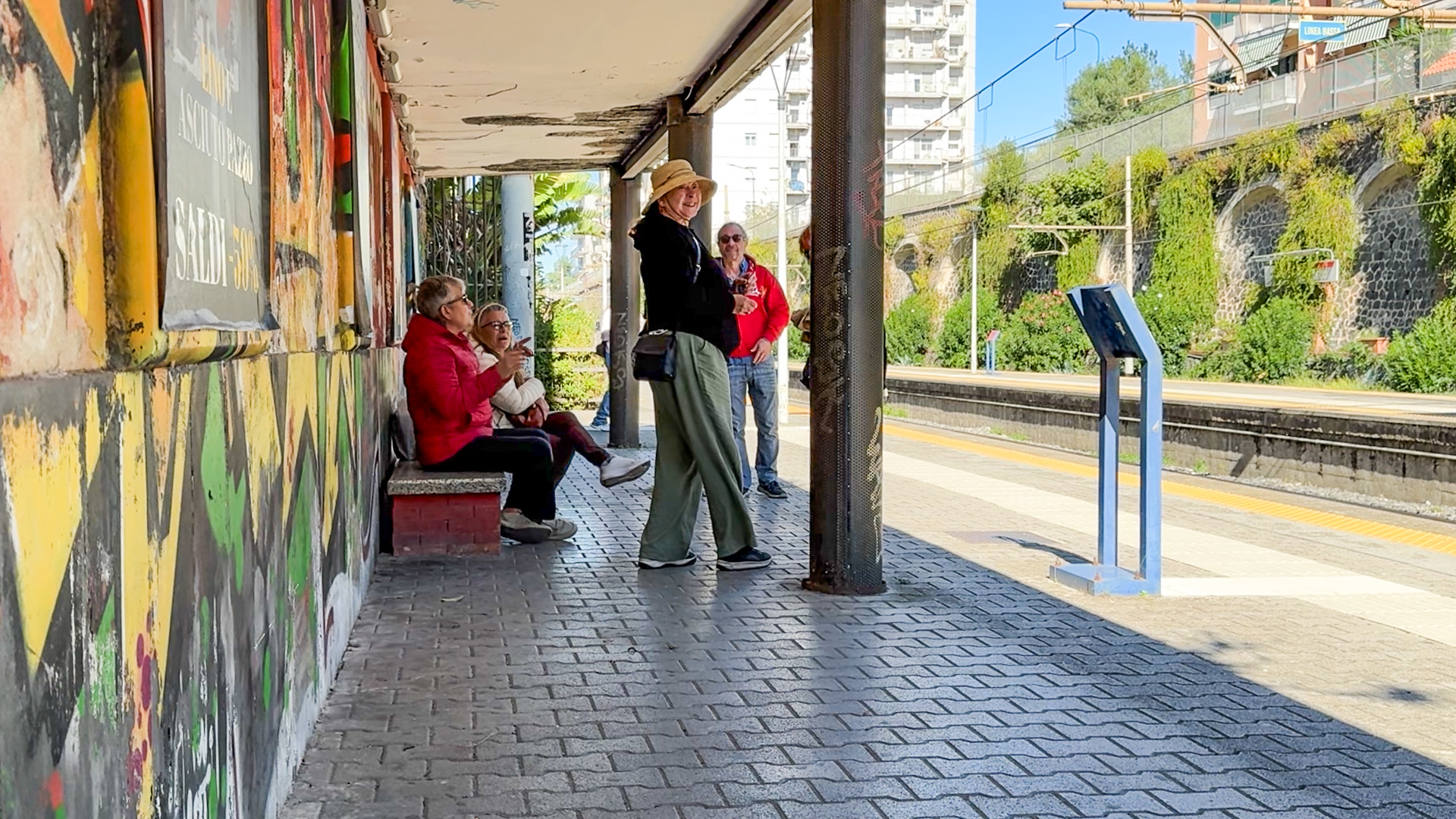
At the train station, Poldi triggers a loud Italian discussion ranging from train schedules to politics.
We decided against driving our car to central Naples, our experiences in the suburbs and countryside were harrowing enough. We took the train, hiking to the next town, Torre del Greco, to the train station. We purchased tickets and found ourselves on a platform on one side of the tracks. My sense of east-west was that we should be on the other, so I asked Poldi how she knew which was the one we should be on.
The station markings were inadequate, so she approached a man to ask if this was the right platform to go to Naples. It was a simple question, yes or no, but he gave a lengthy answer (in Italian of course, which I did not understand).
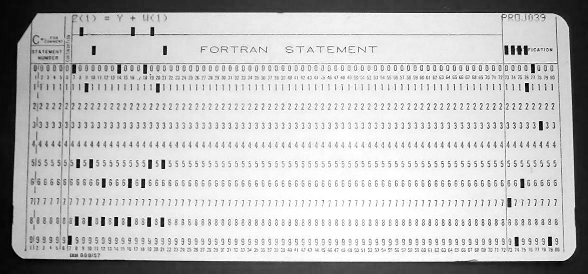
This punch card identifies the parts of a Fortran statement. The first five columns contain the line number, unless column 1 is a “C”, which turns the statement into a comment. Column 6, if marked, usually by an “X”, turns it into an extension of the previous statement. Columns 7-72 hold the Fortran statement itself, and the rest are an optional “sequence field” for use by the programmer as desired.
I wrote my first program at the age of 15 using a coding pad provided by my dad, who was managing an early computer installation for his employer, General Mills. It was 1968, and programs were drafted on these pads, which were basically a grid with 80 columns and maybe two dozen lines. The program statements on the pad would later be transcribed by a keypunch operator onto punch cards, one line per card, and then fed to the computer by a card reader that could sense the holes in the cards and turn them into bits in the computer’s memory.
I didn’t understand the details of how computers worked, but I was able to figure out how to write a series of statements in a programming language (Fortran) to do something I thought was cool: print out the coordinates that I could plot on graph paper (yes, that’s how it was done), to create an Archimedes Spiral; the path traced out by what I imagined to be an insect crawling on a ruler that was rotating around the starting point.
It was an ambitious goal, and I had to think hard about how to do it. I had to learn about loops, conditional IF statements, and distinguish between integers and floating-point numbers. And how to format them and print them out. In the end, I think I was able to do it on one page. I carefully wrote each line on the coding pad and gave it to my dad, who promised to take it to work and run it on the computer (I later learned it was an early Control Data Cyber 6600 model which occupied a large room).
He returned that evening with the result, a line printer output on “computer paper”, large folded pages with detachable tractor feed sprocket edges. I looked at it and saw numbers printed along the left edge. Pairs of numbers, one pair per line on the page. These were the XY Cartesian coordinates I was looking for!
I pulled out my pages of graph paper and started plotting them. I marked a dot at each XY location, and soon I saw that as I connected the dots, a spiral shape was forming! I was quite excited. This was the experience I had of writing my first program.
I later learned that writing a program that ran correctly on the first attempt is a rare thing. And I also heard that my dad teased his staff of professional programmers to try and be as successful as his teenage son.
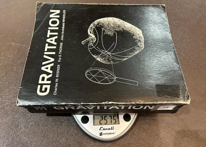
In 1974, my roommate and classmate Jeff Harvey came home in a highly excited state. He had just purchased the recently published book, “Gravitation”. It was unusual for a reference or textbook —not just because it was a paperback, but also because it was immense. It had large pages and it had a lot of them: over a thousand. And each seemed to have sidebars, notes, and explanatory boxes or illustrations to augment the text, which itself was written in a distinctly non-textbookish, conversational style.
We had both taken courses in special relativity, but general relativity, which explains gravity, was an advanced topic. And Jeff was eager to dive into it. He set himself a goal of digesting some portion of this massive book every day.
The authors of the book were unknown to me at the time but they would become familiar names as I continued my physics education. Charles Misner, Kip Thorne, and John Wheeler, were collectively referred to as “MTW”, which became the moniker to brand this monumental work.
Misner and Thorne were students of legendary physicist John Archibald Wheeler. Wheeler’s distinctive style can be inferred from his coining of popular words and expressions such as “black hole,” “quantum foam,” “wormhole,” and “it from bit” (existence from information).
Misner had a distinguished career in general relativity and cosmology, and Thorne, in addition to popularizing black holes and time warps, spearheaded the effort to build gravitational wave detectors, LIGO, for which he received the Nobel Prize in physics in 2017.
I have encountered these names off and on over the years as my interests have followed the remarkable science yielded by space telescopes, particle accelerators, and gravity wave detectors. I marvel at the things we have learned in my lifetime.
My career was initiated and informed by my study of physics, but veered in other directions. My roommate Jeff, on the other hand, completed his goal of reading and understanding the book Gravitation, and went on to become a noted physicist in his own right, making contributions to string theory and teaching relativity to the next generations of physics students at the University of Chicago.
I was motivated to describe this old memory of Jeff’s enthusiasm for a textbook because Kip Thorne will be the featured speaker at the Misel Family Lecture at the University of Minnesota later this month. I will be thrilled to hear from one of my physics heroes as he describes the fascinating things he has explored in his career.
Had I had Jeff’s fortitude to digest Gravitation, perhaps I would not remain puzzled over the twins paradox. Even now, it seems I just keep mulling it over, and making this post caused me to add some more to my commentary. Well, since the book is still in publication, maybe it is not too late!
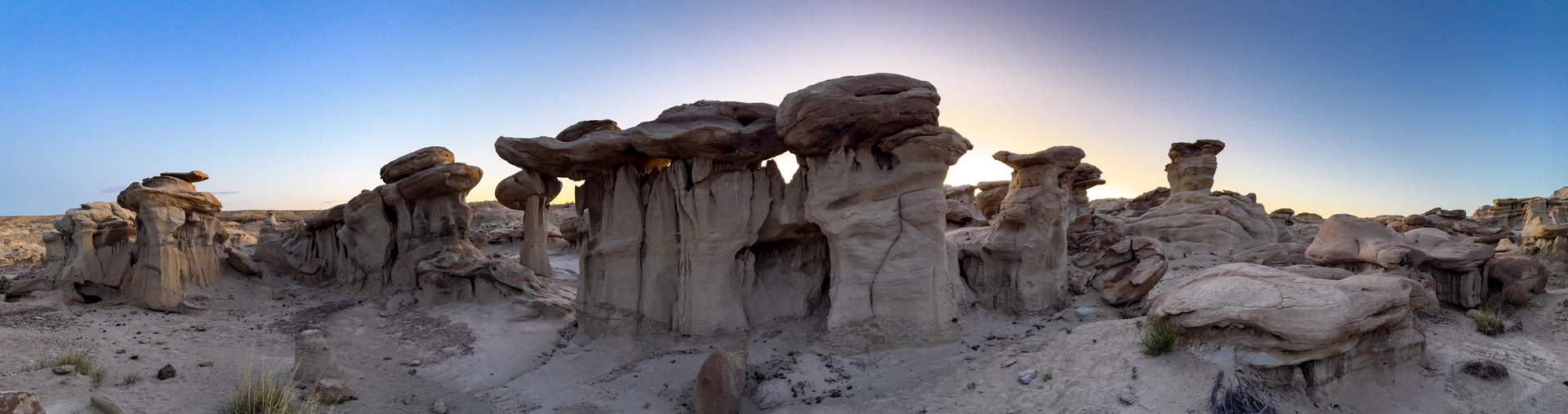
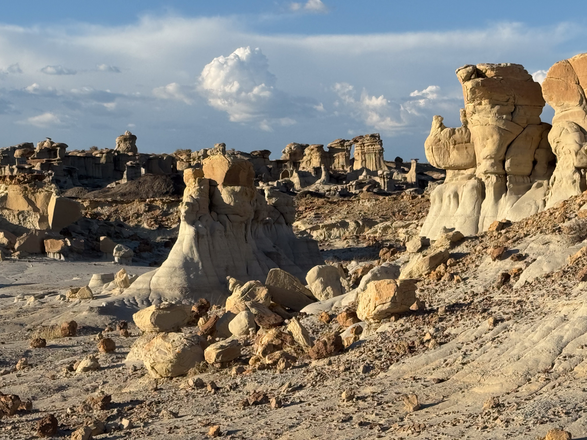
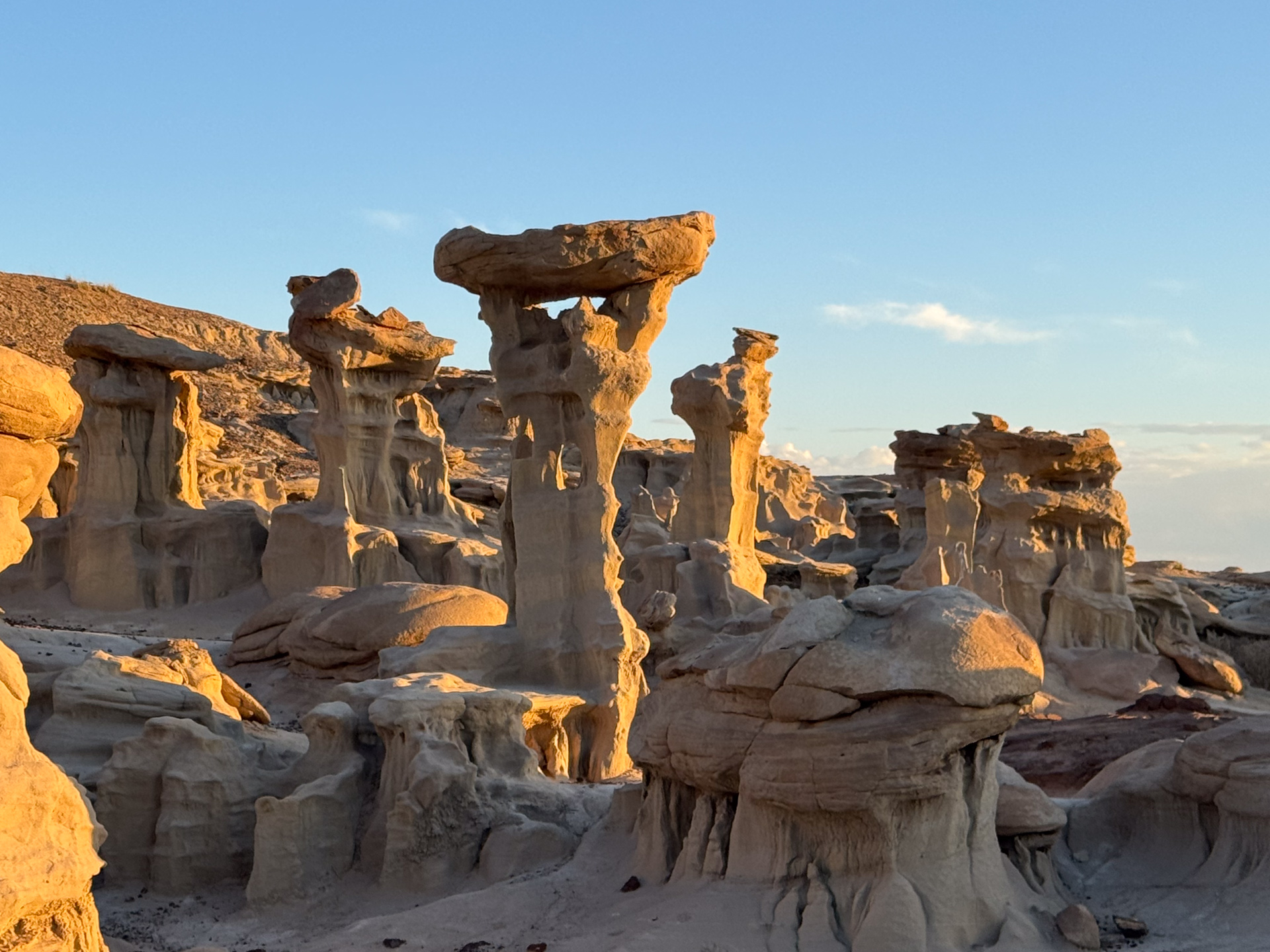
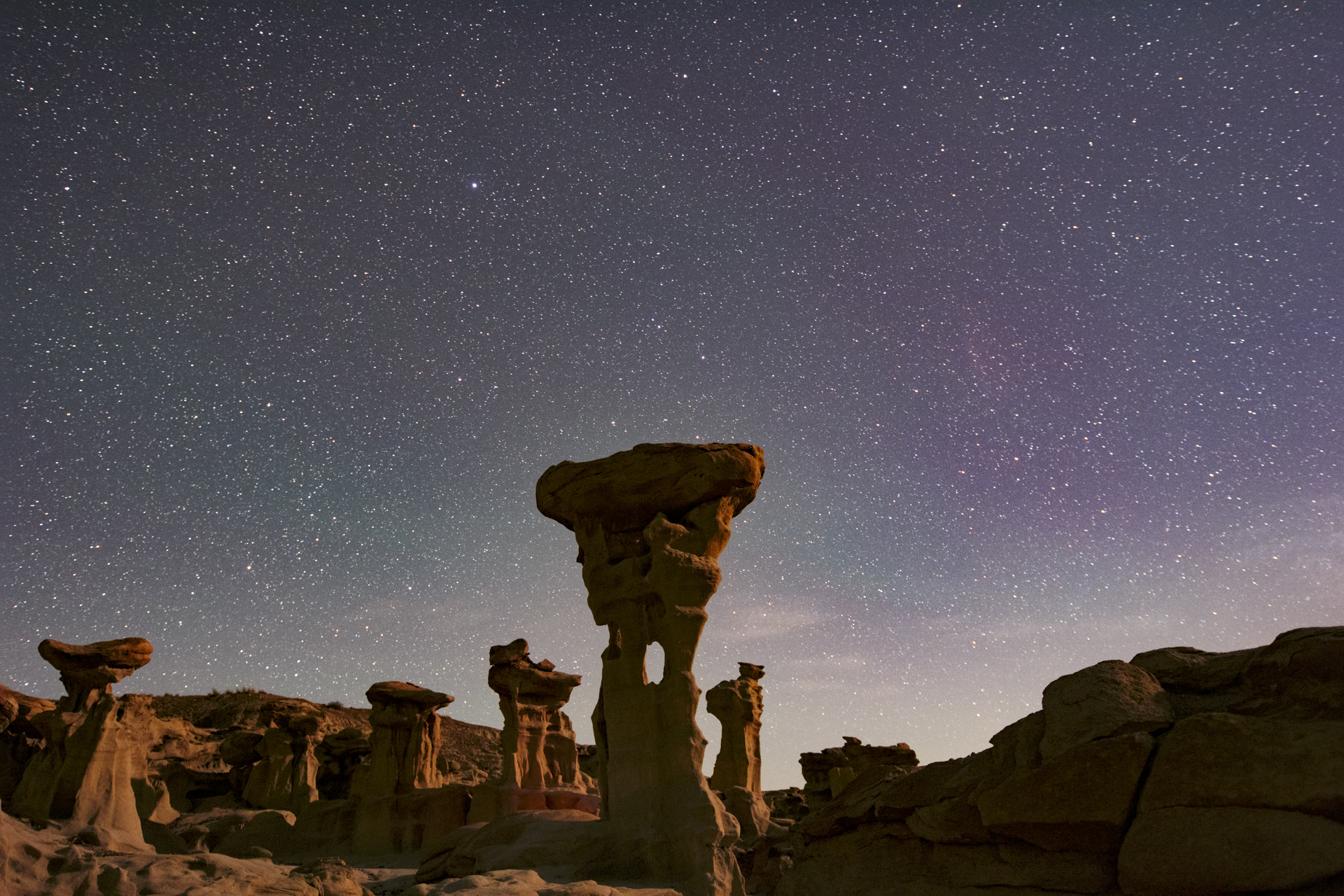
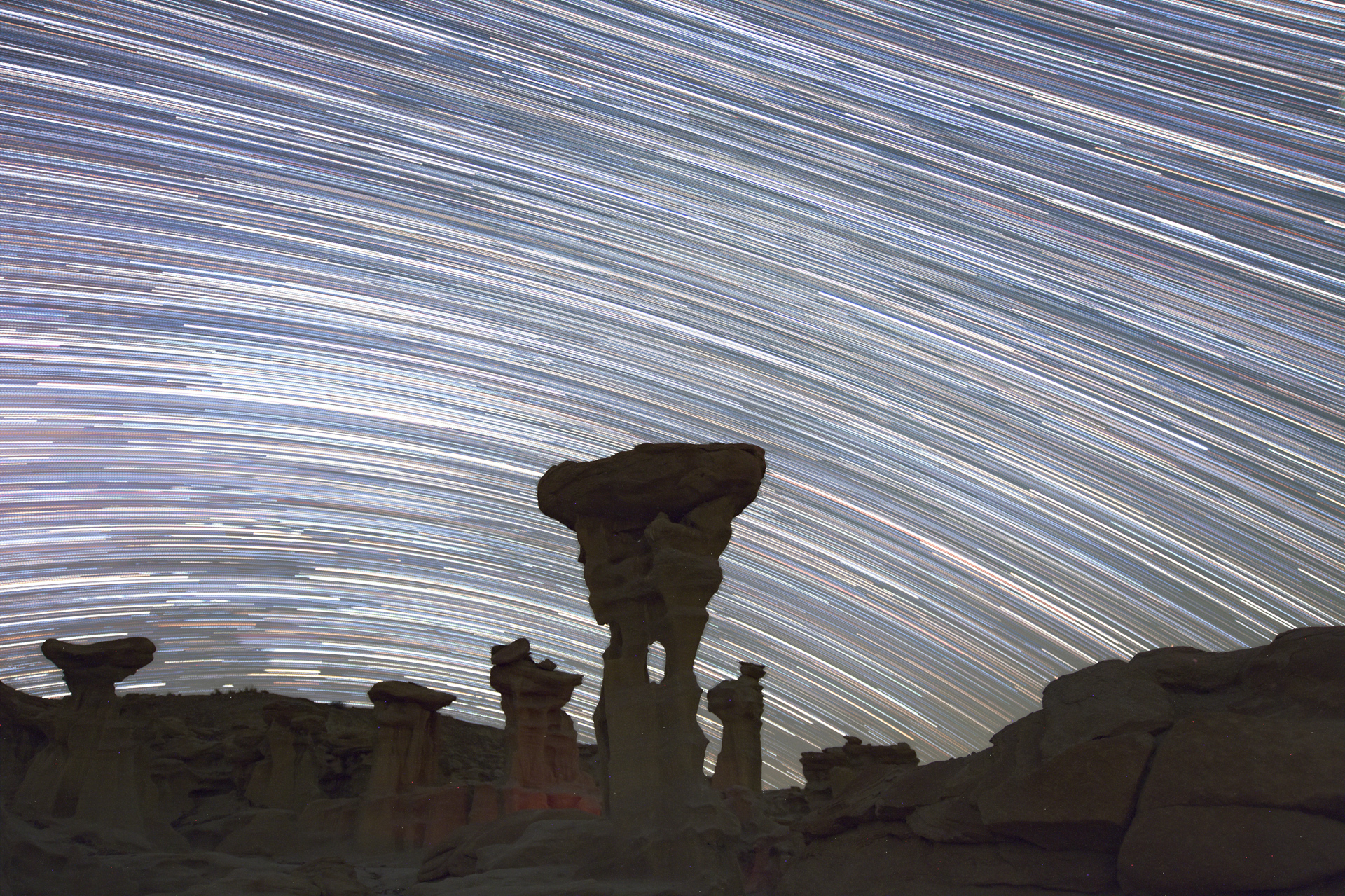
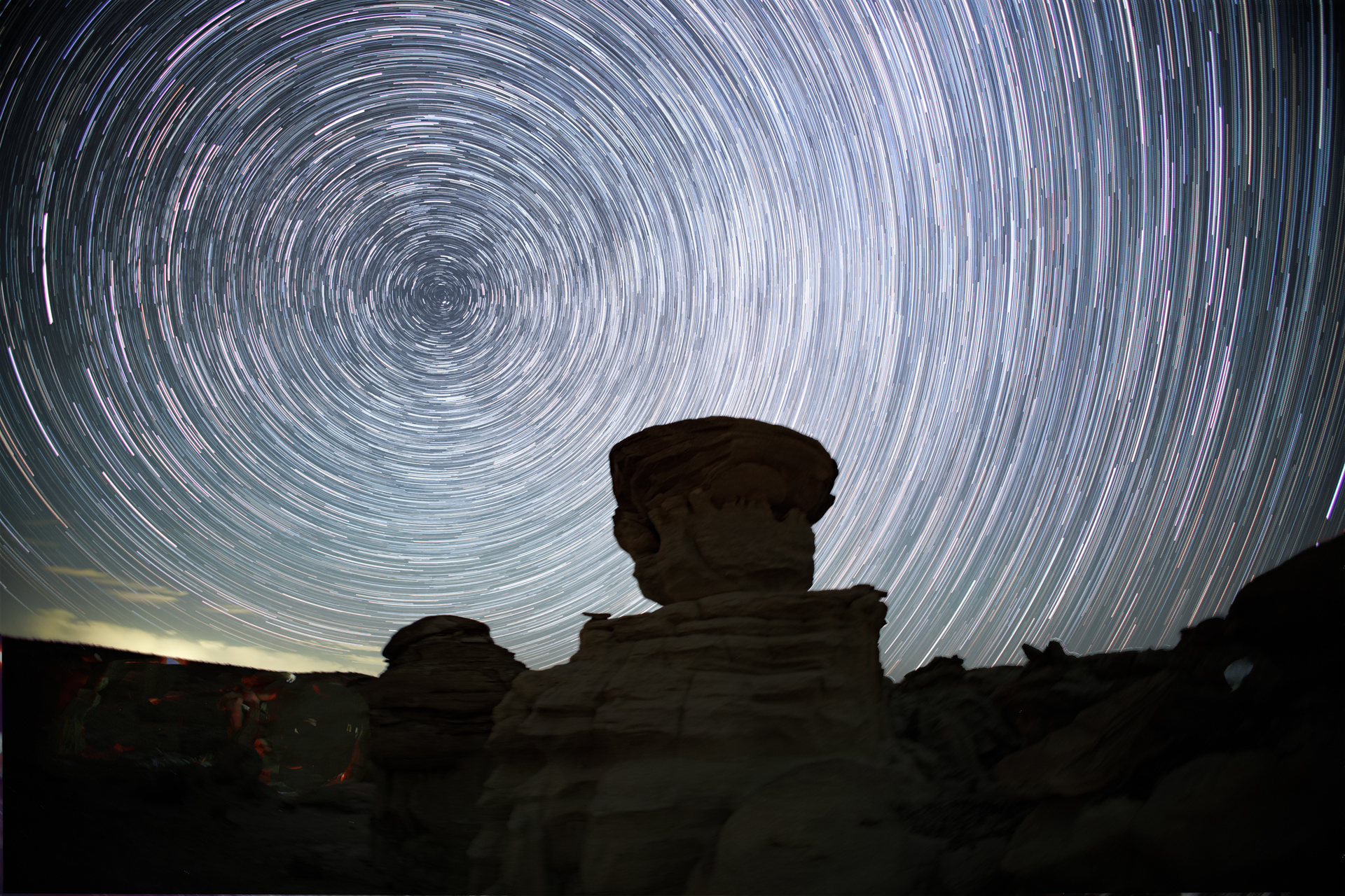
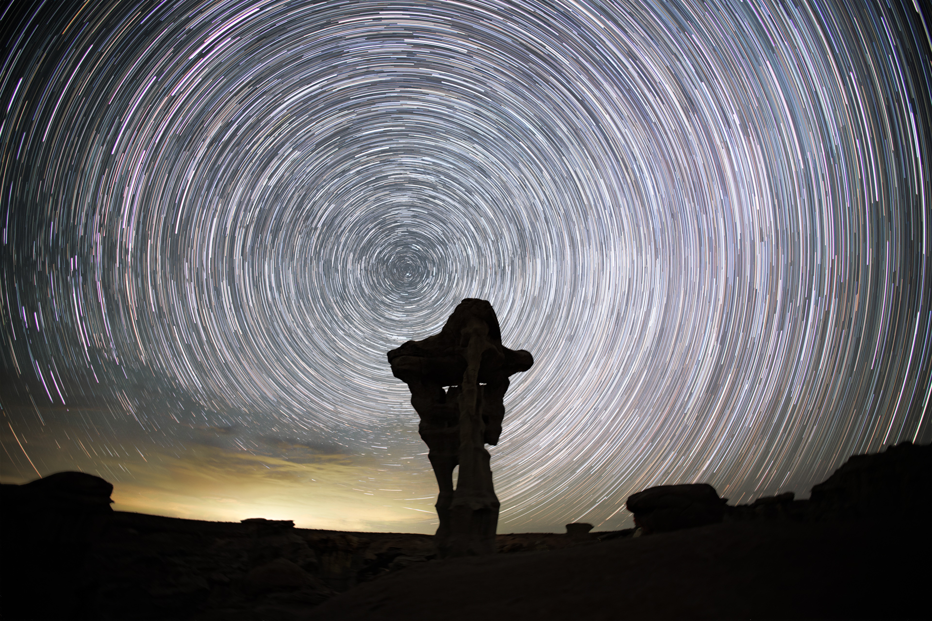
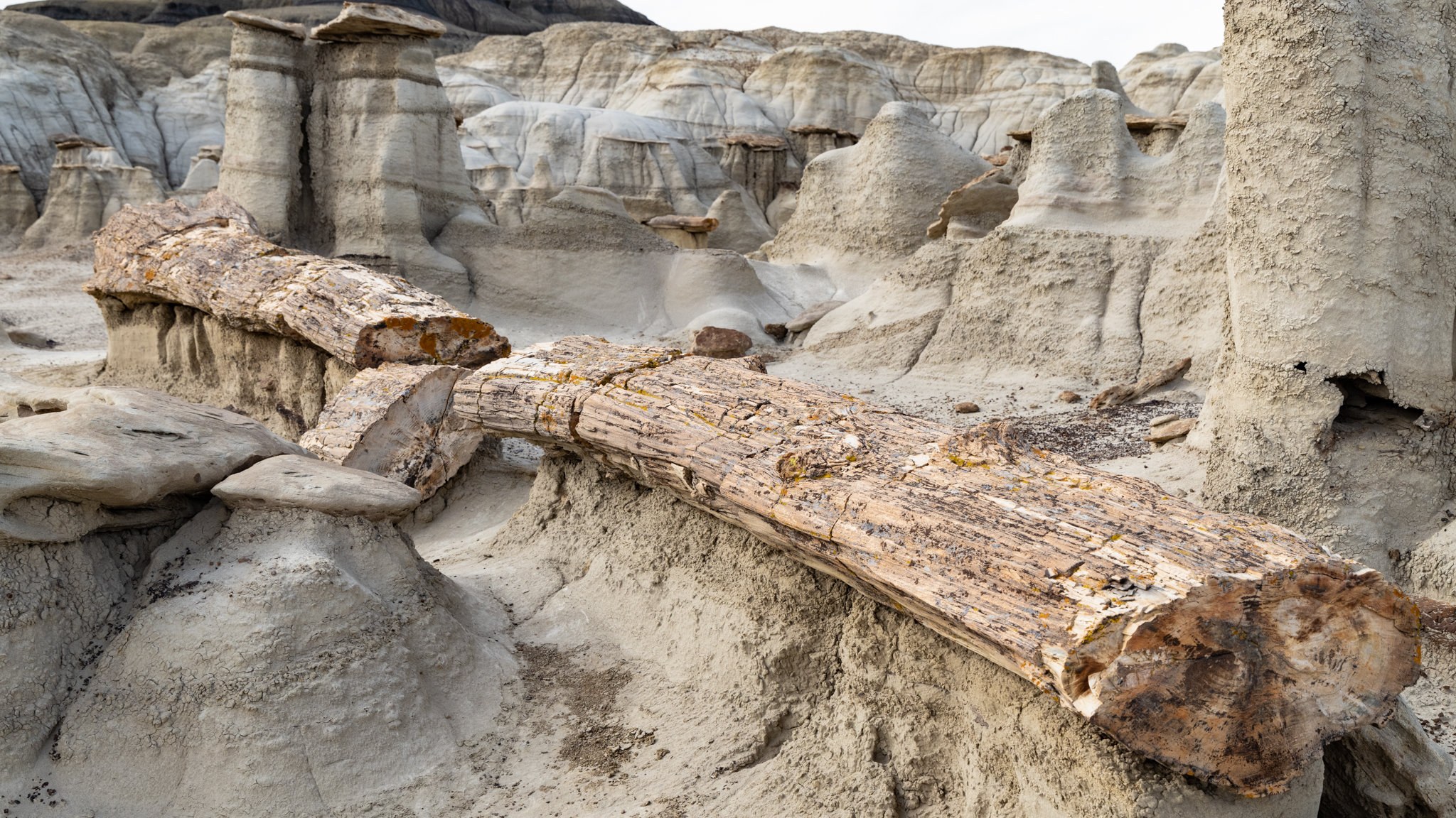
“Mushroom Row,” at the edge of the sandstone theater that hosts the Alien Throne.
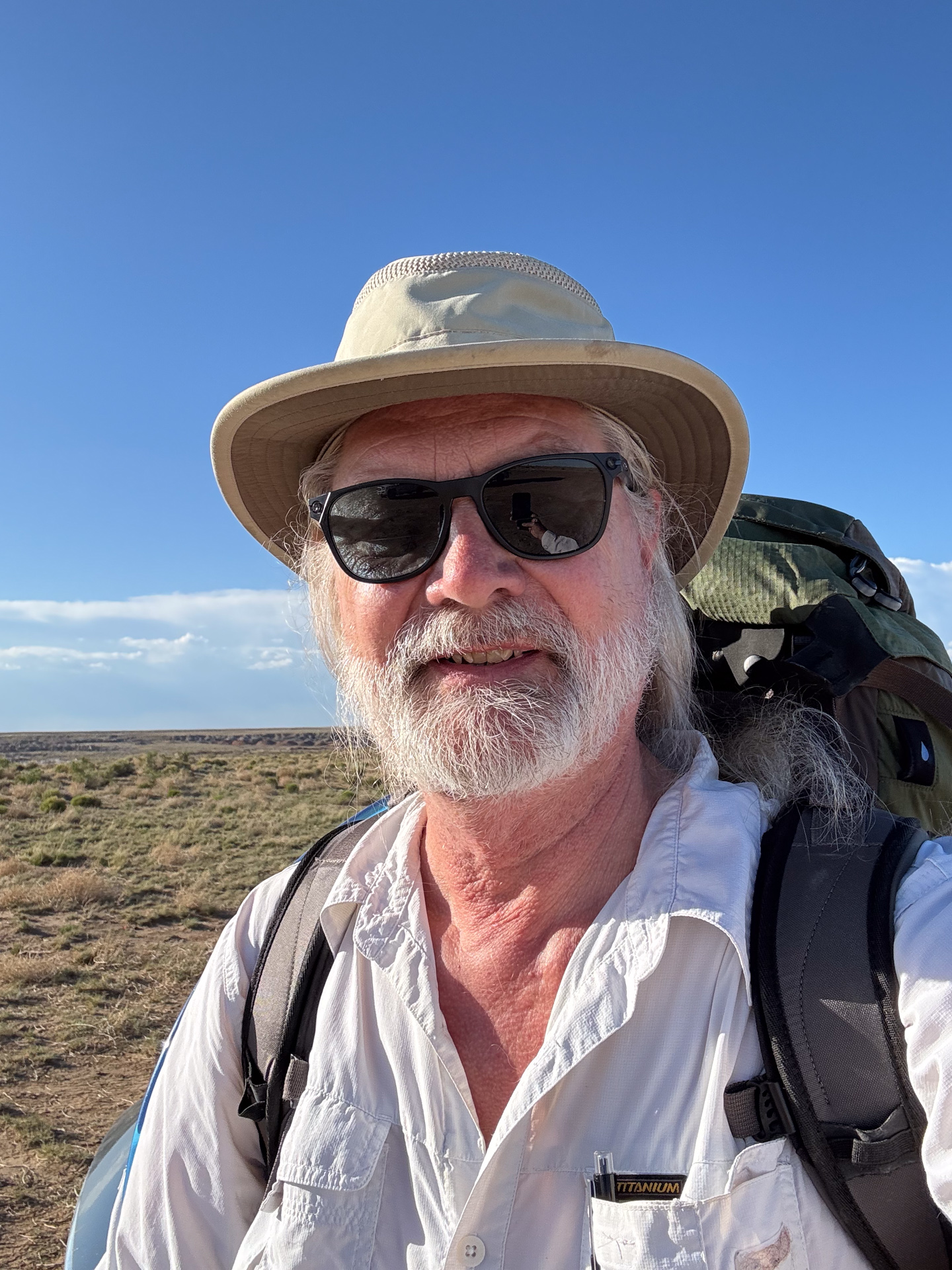
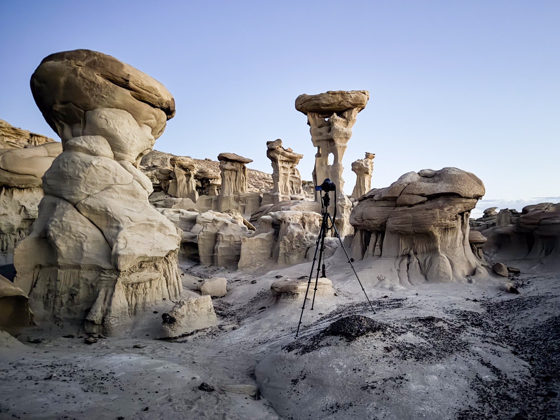
Having performed my reconnaissance by visiting the Alien Throne during the day, I was now ready to consider taking its portrait at night. I had in mind a view that included the Milky Way. And I wondered if I could create a timelapse of our galaxy moving across the sky behind it. It would require planning, equipment, and a bit of luck. A target 1-1/2 hours away from our hotel in Farmington, a further 1-1/2 mile trek across the desert, and an all-night vigil tending cameras, made this one of my most ambitious photo projects.
I had a backpack into which I put my gear: essentials like navigation tools, raingear and first aid, fleece, hat and gloves for overnight temperatures, a sleeping bag for further warmth (and option for sleeping), some snacks, plenty of water, and then the real payload: 20 pounds of camera equipment, which brought the total close to 40. For a single overnight trip, it felt as if I was going out for a week.
My planning [using the PlanitPro app] informed me that sunset would be at 8:20. I wanted to be at the site well before so I could set up and arrange my compositions, and also to capture the scenery in the “beauty light” that precedes sunset.
I got to the trailhead later than expected because I’m not immune from wrong turns, even when I “know” where I’m going. And the desert hike also took longer (was it the heavy pack?). The terrain tricked me into some dead ends. But I arrived at the Alien Throne just before sunset. It was spectacular!
And I was alone. I had feared that I would encounter other photographers with the same idea, but it looked like I would not have to negotiate camera positions, something I had never needed to do. So I went ahead and placed my tripods, aimed my lenses, set the exposure and interval timers, and started the shutters clicking. It takes a bit of time and concentration, but this is the pleasure of the hobby for me. Every outing is a new experiment; I add the details of each to my notebook, which then helps me on the next one.
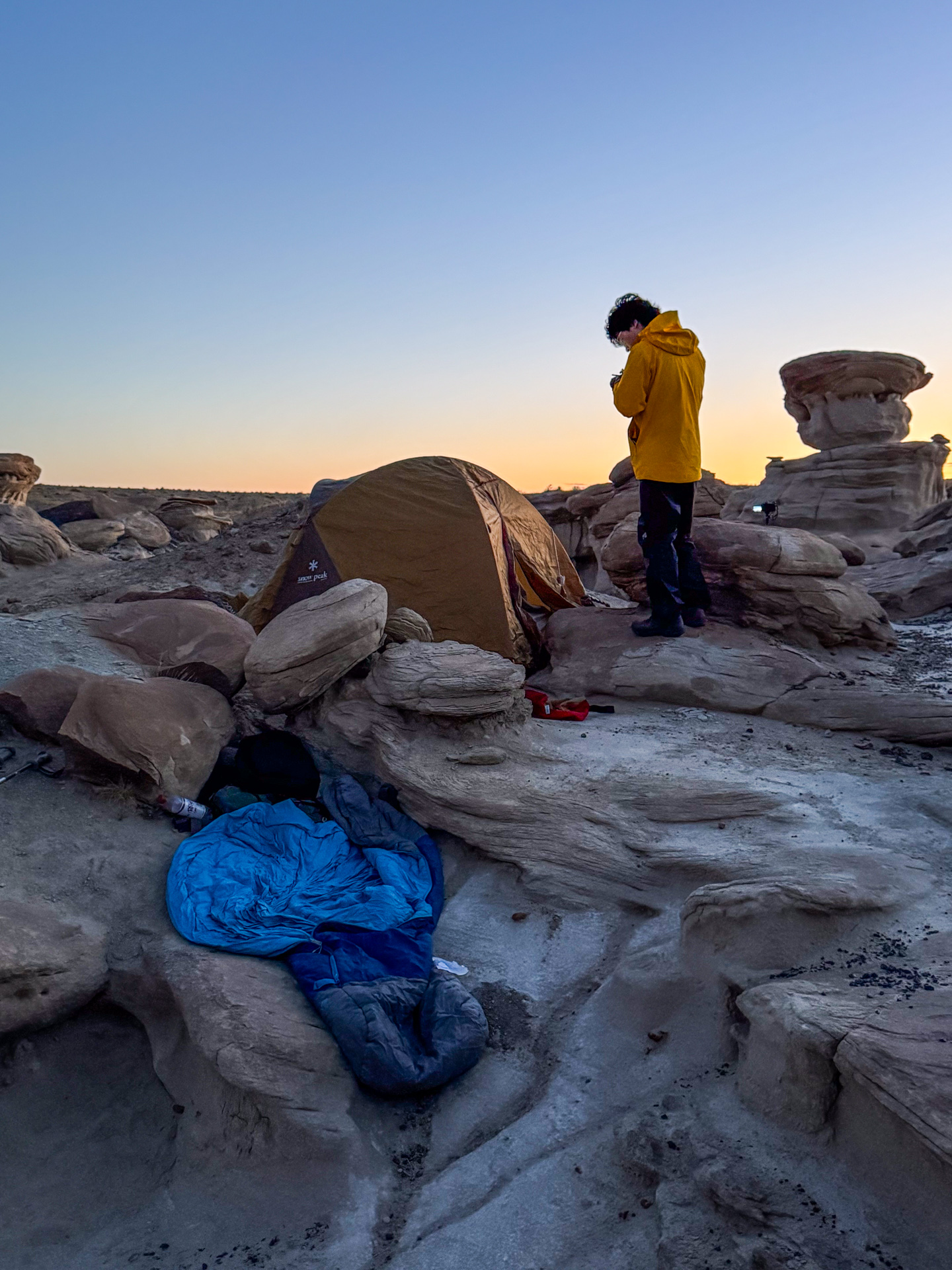
With the cameras now clicking away on their schedules, I could step back and breathe a little easier. I found a niche among the rock formations to set my pack and recline against it. Twilight was advancing, and as I was recording my notes, I noticed lights splashing against the rock formations. Someone was hiking here in the dark, a headlamp lighting the way!
Rather than have them stumble across me in the dark, I called out, “hello?”
A voice replied, and a lone hiker arrived in the sandstone theater around the Alien Throne that hosted my cameras and my nesting place.
As I mentioned, I prefer to be alone during my nighttime star gazing excursions. If I see headlights approaching, I worry about what that vehicle brings. Often, it is a patrol car whose occupants either want to see your permit, or they want to look at Jupiter through your telescope. Though I am more fearful of wild carnivores than humans, I understand why women might prefer to encounter a bear than a man.
In this case, it was a student, recently graduated from UCLA, exploring the country before returning to his home in China. He had acquired a camera and discovered the cool startrail effects that could be obtained at night in unique settings like the one we were now both immersed in. It was a shared interest.
We exchanged introductions while he found a location for his tripod and camera. We had similar equipment, even identical travel tripods. Because my cameras were already in place and running, he found a location for his that did not interfere. It was an act of respect for the compositional claims that I had already staked, but also, I think, a reflection of his Asian culture of honoring and deferring to elders. I was pleased, perhaps even flattered, at the respect. There are few perks to being a septuagenarian; this was one of them.
My plans involved keeping my cameras in place and running all night. I needed to make some tracking adjustments and periodically replace batteries. His plans were to gather an hour or so of exposure in one place, and then move to a new location with a new subject and new backdrop. It all worked out with little or no interference. Between camera moves, we chatted and exchanged information from across our generations, homes, and cultures.
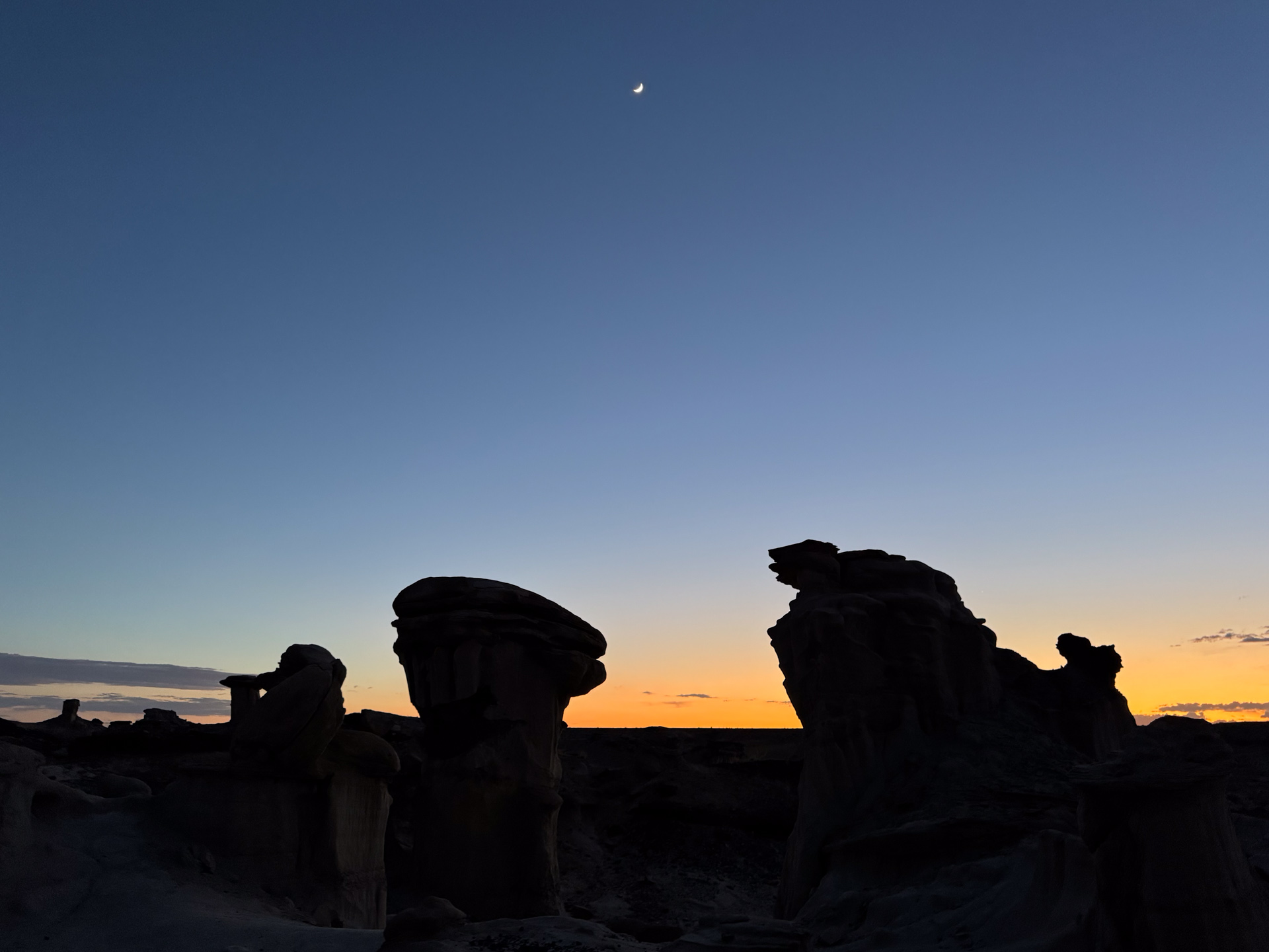
As the desert cooled down, we took refuge. I climbed into my sleeping bag, and he found enough surface area to pitch a small tent. I faced the open sky and watched the young moon set, the stars drift past, and the Milky Way rise from the east. “Sleeping under the stars” is a romantic notion, and a rare opportunity in modernity’s protected life. It is not easy to do in my midwestern home, where the sky is often cloudy and the air is filled with insects, but here in the desert, it is a wondrous experience.
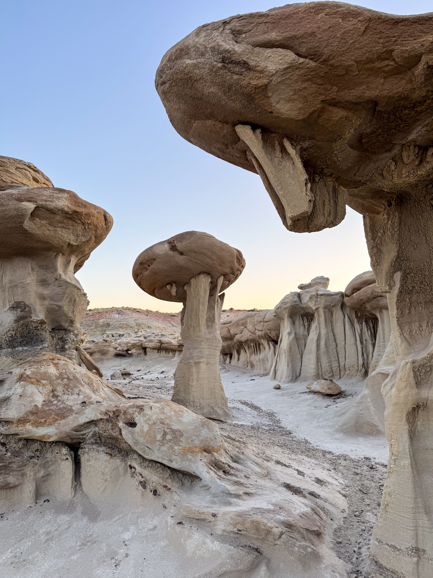
The night passed pleasantly by, in 90 minute segments, per my alarms to get up and attend the cameras. In this remote location far from city lights, the sky transitioned from one of the darkest possible, to the natural progression of twilight leading toward sunrise. The Milky Way faded into the brightening sky. My startrail and timelapse work was now complete, but I wanted to see the hoodoos in the morning sunlight. I was not disappointed.
As I started packing up my gear for the trek back, my fellow photographer brought out another of his gadgets: a drone, which he sent overhead to capture stunning views of the terrain in which we were immersed. I think this is technically not permitted in a BLM wilderness area, but I couldn’t deny how cool it was, and no one else seemed to be around to complain.
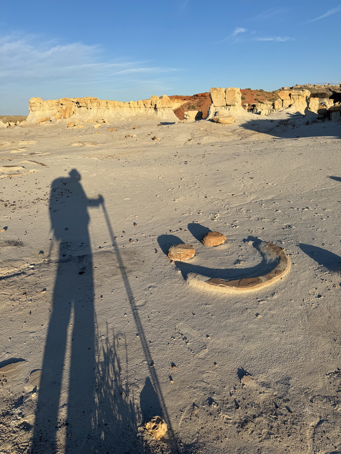
I finally said goodbye to my overnight companion. We exchanged email addresses, and I hope to share photos with him. I then hoisted my pack and headed back. The water weight had diminished, and I admired the morning light on the unique desert features. I was exhausted, making the night’s experience all the more valuable.
Here are some photos from that beautiful night. The first set was taken during daylight, the next from my nighttime exposures. Finally, I offer the timelapse video composited from the frames I acquired. I hope you enjoy them.
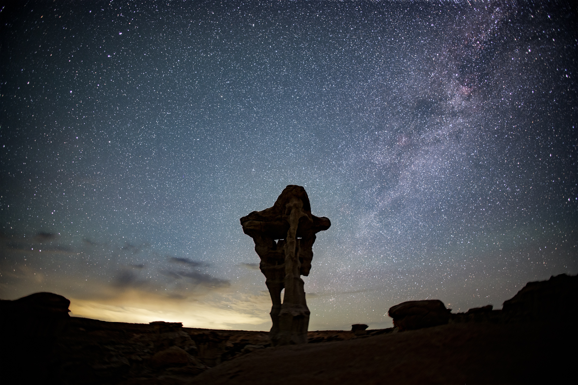
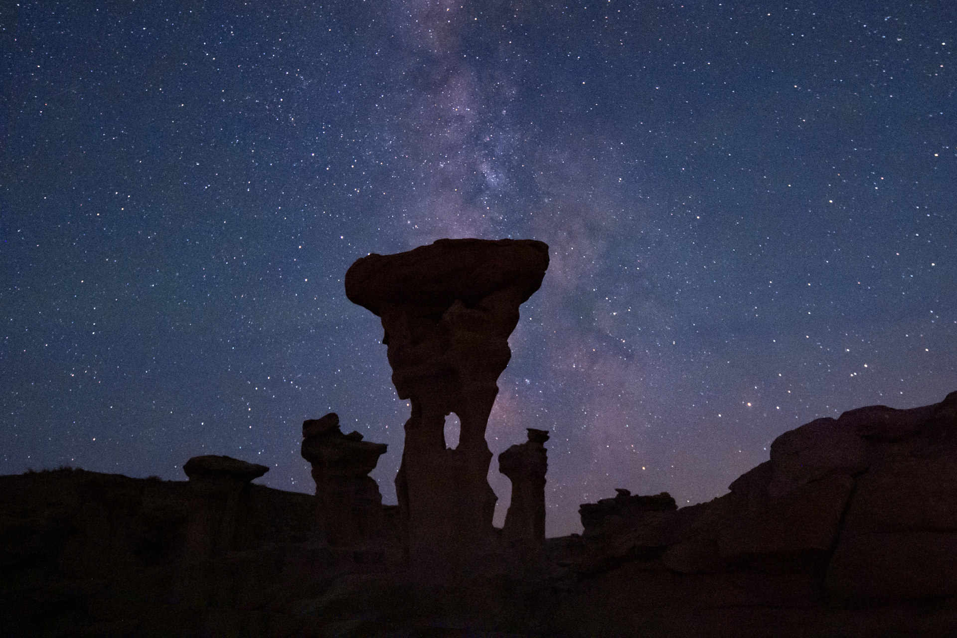
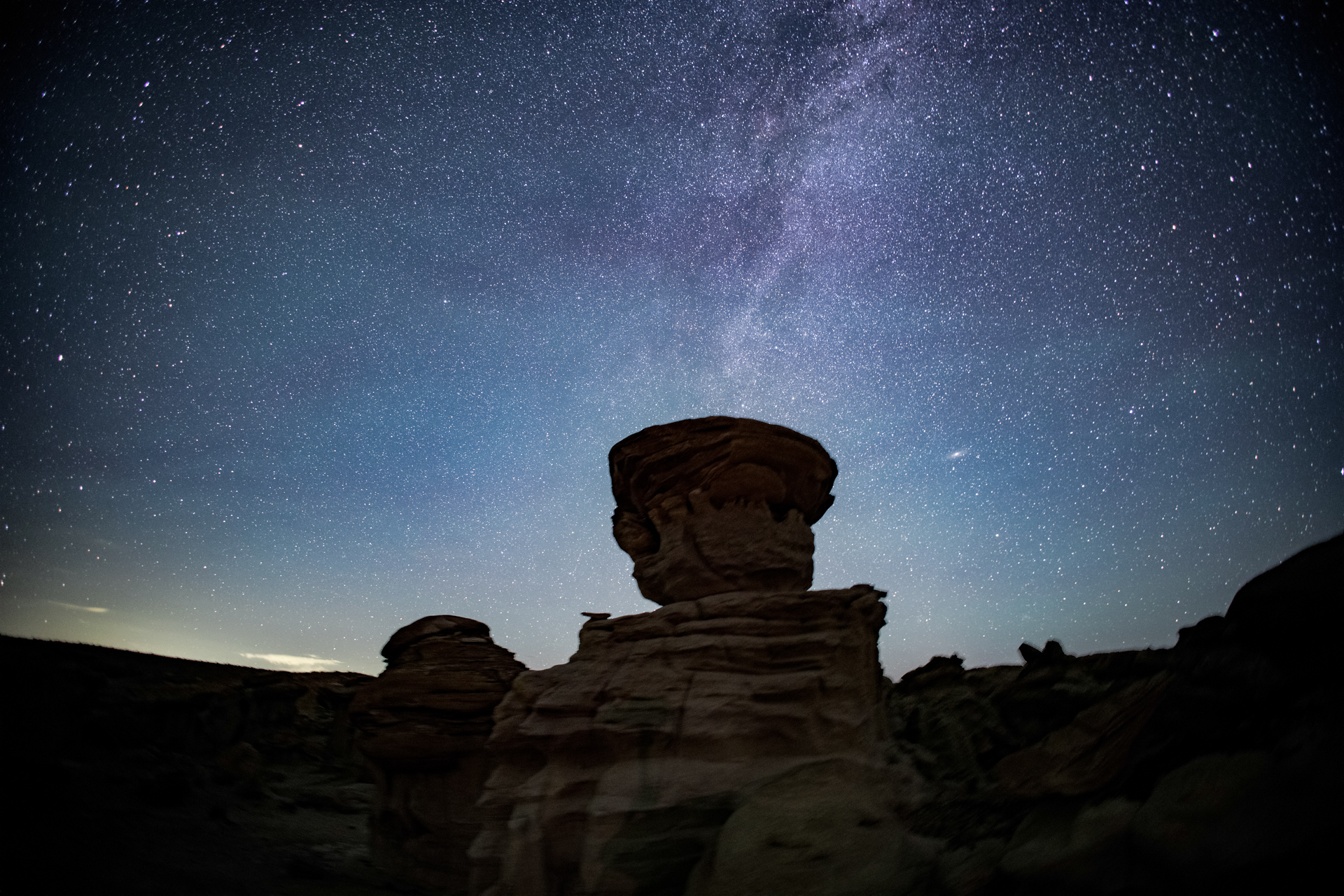
As I start out on my hike to the Valley of DreamsTypical of the landscape along the routeThe Alien Throne among its neighbor thrones in this theaterThe moon is a few hours behind the sunMy camera and tripod, trying to emulate a hoodoo and fit in with the crowd.The niche containing my pack and sleeping bag, with Weiheng and his tent behind. The “Giant Mushroom”, surrounded by a ring of similar structuresI encountered this on my hike back the next morning. It is exactly how I felt.Photos of my hike to and from the Alien Throne. Click to enlarge, then scroll through.Alien Throne in moonlightMilky Way to the northMilky Way to the southA mushroom hoodoo and Milky WaySouthern star trails. Look for the celestial equator.Circumpolar star trails, one-hour exposure.Photos from my overnight session in Valley of Dreams.
A link to the timelapse sequence. Enlarge to full screen for the full visual experience.
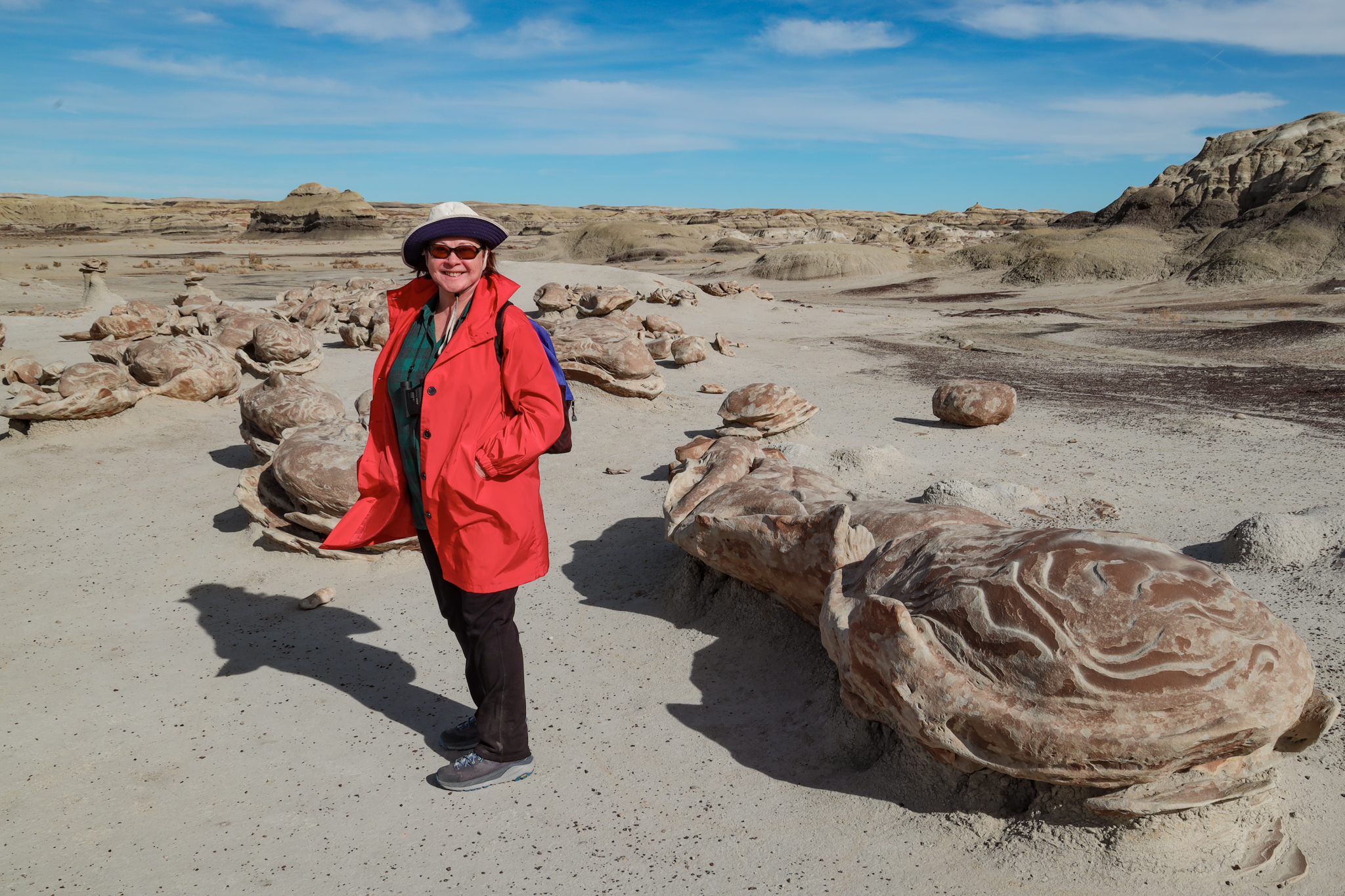
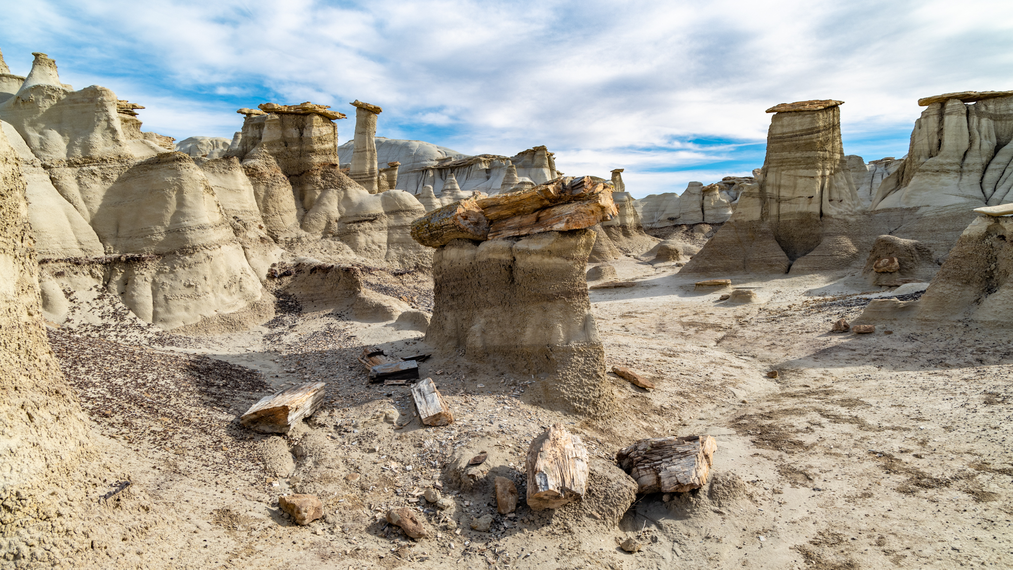
The American Southwest is an amazing, mysterious, and visually stunning place. I’ve had a fascination with it my whole life, and make excursions whenever an opportunity arises. A few years ago, Poldi and I discovered an area in New Mexico with remarkable geologic features: badlands, hoodoos, and petrified wood! It was the Bisti Wilderness Area, held apart from private and reservation land by the Bureau of Land Management for the benefit of the public. It is only very lightly “managed” by the BLM. There are no visitor centers, no picnic areas or campgrounds, and no trails. There is a small parking area at the end of a difficult dirt road, marked by a signpost and featuring an outhouse.
Despite the lack of trails, we were able to follow the breadcrumb descriptions posted online by a photographer who explores Bisti for its photogenic subjects. We located and visited the Alien Egg hatchery, a 30-foot-long petrified log, and a hoodoo village. In the years since, we have wanted to return and explore more of this fascinating area.
Poldi in the nest of alien eggsPetrified logHoodoo villagePhotos of Bisti Wilderness, November 2022. Click to expand, then scroll
We were able to do so this year. The timing was right—late Spring, before the desert becomes intolerably hot. We both researched and found several more sites with novel features bearing names like “King of Wings”, “Chocolate Penguin King”, and “Alien Throne”. These are not roadside points of interest with explanatory markers; they are deep in wilderness area, accessible to intrepid hikers willing to explore the desert and locate them. Those that are successful bring back stunning photographs.
Those photographs inspired us to consider visiting them. A particularly novel feature, “The Alien Throne”, made me wonder if I could get a picture of it with a night sky backdrop. I read the accounts of others who had made the trip. Maybe it was possible!
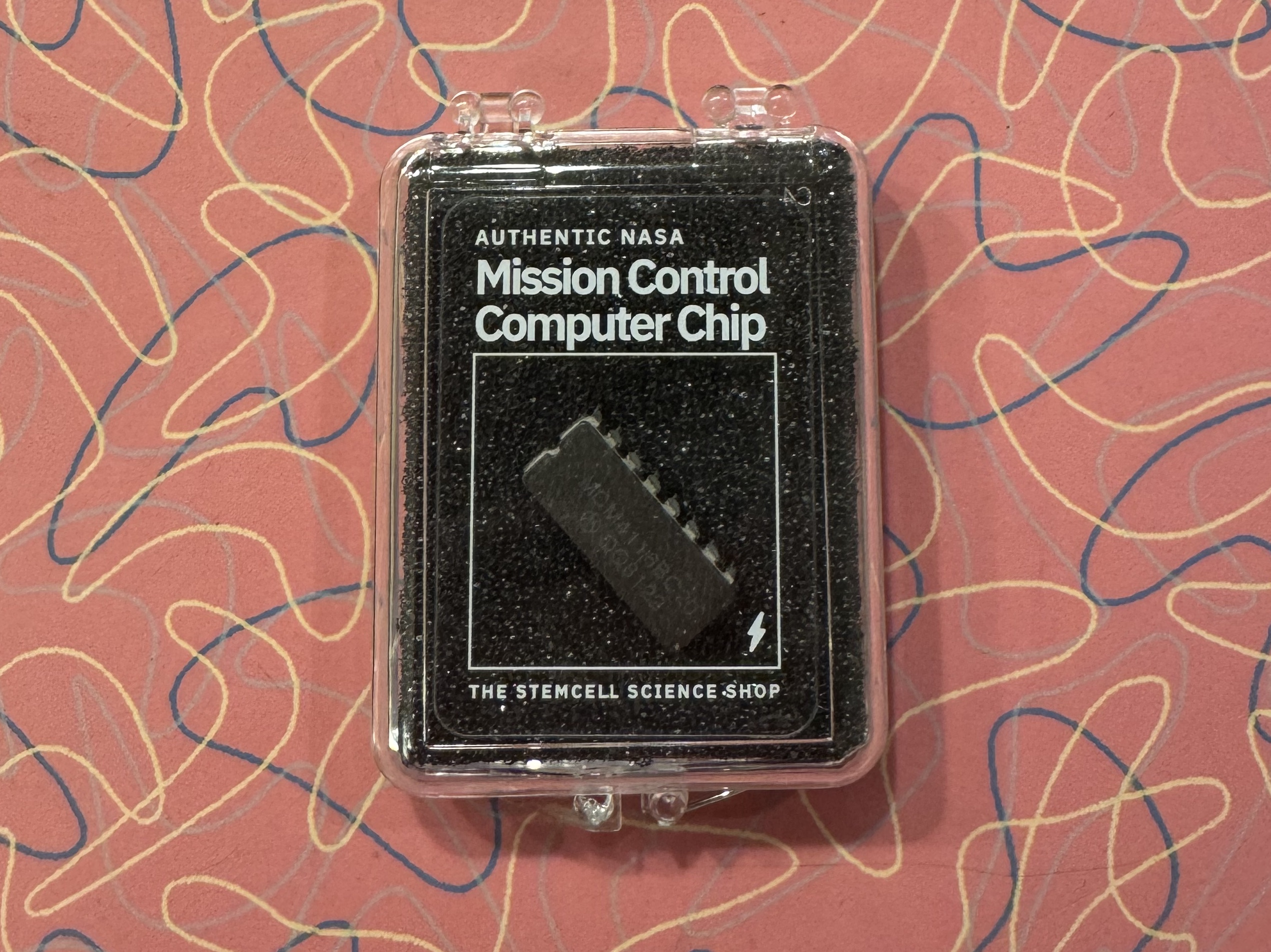
I was recently presented with a gift from a young family member. He thought I would get a kick out of a “NASA Mission Control Computer Chip.” And I did, even more than he could have imagined.
I suspect that an entrepreneur had acquired some decommissioned NASA equipment and found a way to monetize it by stripping the chips out of their sockets, packaging them, providing a backstory, and selling them to nostalgia seekers, space history nerds, and millennials looking for novel gifts for their boomer relatives. This is not a criticism. This is a fine way to keep these components from ending up in a scrap heap headed to a landfill and instead make a final tribute to a remarkable human project.
To someone born after the Apollo moon landing program, the artifacts of those times must seem just that: obsolete artifacts. There are still computer chips, of course, but they are smaller, more complex, and come in highly sophisticated packages that look nothing like those of that era. Just look inside a cell phone.
My pleasure at receiving this gift was not just the experience of once again seeing a 16-pin DIP (“dual inline package”). It was also the recalled memories of designing circuit boards with them in the 1970s. At that time, I worked for a small company that made geophysical instruments. We had employees, mostly women with fine motor skills, who hand-assembled these DIP packages, along with other electronic components onto circuit boards, soldering them into place and wiring the boards into the instrument chassis. I contributed to the design of those boards by figuring out how the digital chips needed to connect to each other.
I was curious what exact chip from mission control I had received. When I looked closely, I could see the part number stamped on its top: MCM 4116 BC20, along with the manufacturer’s logo and date code (8122- the 22nd week of 1981). This part number seemed familiar to me. I looked it up and found it to be a memory chip with 16,384 bits. Now even more memories flooded in! This was a milestone memory chip in its day!
And it was the very chip I had used in one of my first memory board designs. I was quite intimidated because it was in a class of memory called “dynamic,” which was a euphemism for memory that forgets rapidly. In order for it to not forget, it needed to be refreshed. And I had no idea how to do that.
There are now many different technologies used to store data, but in the 1970s, there were only a few, categorized by type. Read-only-memory, ROM, had data permanently etched in place. It was good for storing data that would never change, like program code and conversion tables. The other major memory type was, and is, random access memory, RAM. This is memory that can be written with any data pattern, and accessed later, in any order (randomly) to recover it. There were two types of RAM: static and dynamic. Static memory, SRAM (pronounced “ess-ram”), would retain its data state for as long as it was powered on. Dynamic memory, DRAM (“dee-ram”), as mentioned above, would fade away with time, measured in milliseconds.
Why would anyone bother with memory that didn’t remember much?
Capacity. It was possible to fit much more memory in a DRAM chip than an SRAM chip. This was due to the additional complexity (transistors) needed for the static memory cell to stay, well, static, and hold its value. In contrast, the DRAM cell comprised a single capacitor, a place to store electrons. As a result, DRAM chips had 4X the capacity of SRAM for the same size or cost.
Unfortunately, the electrons on the DRAM capacitors had the tendency to leak away. This can be compensated for by sensing the memory value before it fades, and then re-charging the capacitor to its original state. It is a lot of overhead to visit every memory cell, read it, and re-write it before time runs out, but memory was valuable, and the effort was deemed worth it.
I knew little of these underlying details of memory chips in 1977, but I did know that it was easy to design circuits using SRAM chips. Connect them up, and they seemed to “just work”. On the other hand, on hearing about the onerous demands and complexities of using DRAM, I was scared. It just seemed too complicated, and I didn’t think I knew enough to take it on. It might be really hard. So I resisted this project.
Eventually, I had to face the task. I obtained the data sheets and application notes for the DRAM chip I would be using: the 4116, just like the one recovered from mission control. In the days before the internet, this involved procuring the published data books from the parts vendor. I then dove into learning about dynamic memory and how to manage it.
I learned the basics that I described above, and I also learned that I didn’t have to read and re-write every cell. The chip could help out with that task. Memory was arranged in rows and columns of cells. If I could access each row, the chip would take care of refreshing all the columns in it! Other chips were available to invisibly help with accessing each row.
As I learned how to make the control circuits keep the memory refreshed, I realized that my fear had been unwarranted. This wasn’t so awful. It was not over my head. I knew how to do this!
I would eventually become skilled enough to use DRAM chips in high-end color displays, sometimes devoting many bytes of memory for every pixel, an unheard-of extravagance made possible with the increasing capacity and dropping costs of DRAM.
I took away a lesson from all this. Something may seem incredibly complex, like the ubiquitous example of “rocket science,” but a complex field is not necessarily a difficult field, especially to those who are in its midst and have learned along the way. As one learns a little, the next questions to ask become apparent and guide you to learn more.
As a result of this experience, I became less hesitant about taking on new and unfamiliar challenges. Confront the challenge and the results are better, and you are better.