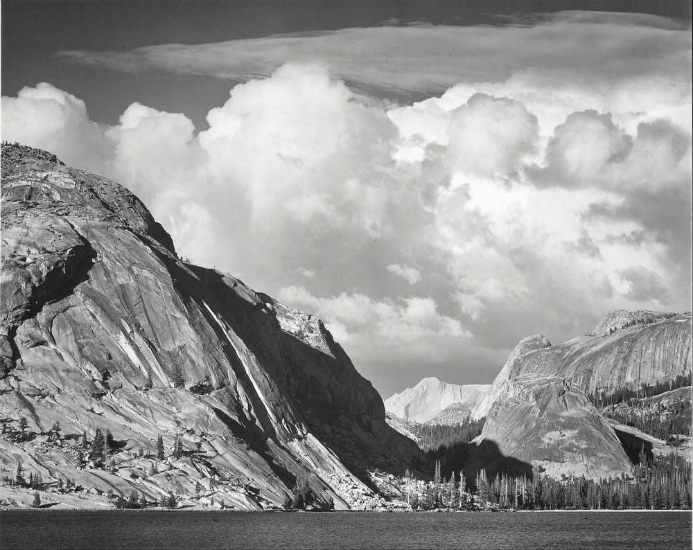
Tenaya Lake, Mount Conness, Yosemite National Park, by Ansel Adams.
My dad’s younger brothers were favored uncles; they were grown-ups, yes, but they were fun. Bob, the youngest, was only a half-generation away from me. After spending a year in Viet Nam with the Navy, Bob had returned to Alameda California in 1972 to complete his service. He arranged for my brother Eric and me to spend time visiting him there during our spring break. The week with him was quite an adventure for us teenagers. It left a strong impression of California culture and provided an intimate look into the life of a highly regarded adult. We met the wonderful woman who would become our Aunt Karen. They planned to wed in June later that year.
Their wedding became a focus for the summer, and my dad arranged a complex family summer vacation to attend this event. We numbered seven, and were no longer small enough to all fit into our Volkswagen bug as we once had. Nor could we fit in the large Pontiac Bonneville, later known as the Great White Whale, especially since we were bringing camping gear for Dad’s planned post-wedding vacation activity: backpacking through Yosemite Park. So both vehicles were recruited for the cause. We had four licensed drivers in our clan and could tag-team the drive to California and back.
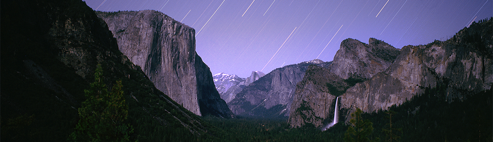
I described this backpacking adventure in a previous post. After that memorable experience, we continued by exploring Yosemite Valley. In addition to the famous views of Half Dome and El Capitan, there were art galleries! Yosemite was the adopted home of a number of artists, including photographer Ansel Adams, who had a studio and school here. Many of his images were on display and available for sale.
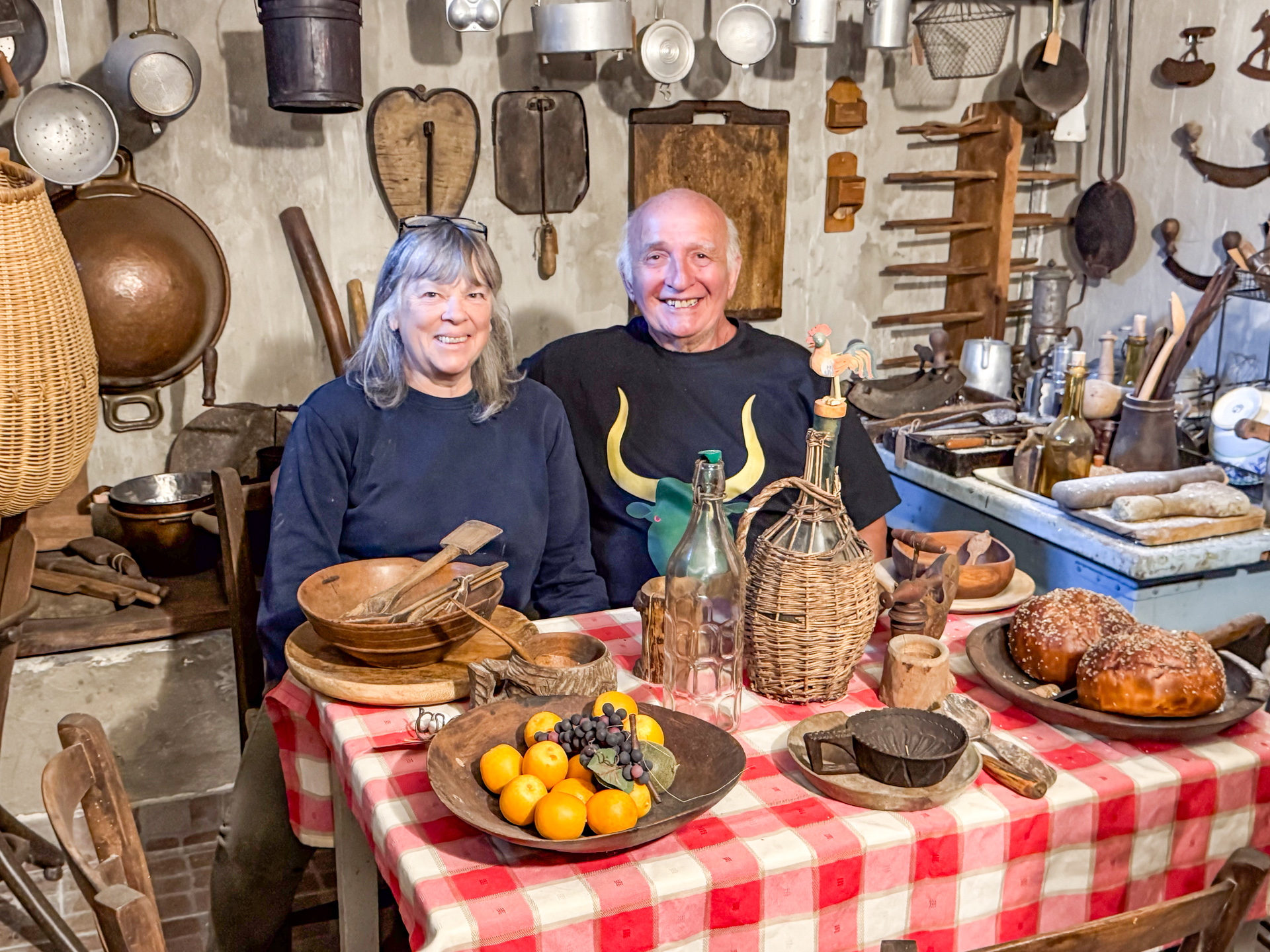
Mario and Rossella are collectors of antiques, especially antique tools, essential devices in the time before the invention and use of engines and motors. In this last album of the series, here are some of their treasures. Maybe you can help identify some of them!
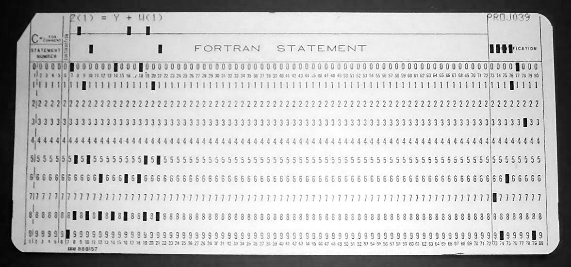
This punch card identifies the parts of a Fortran statement. The first five columns contain the line number, unless column 1 is a “C”, which turns the statement into a comment. Column 6, if marked, usually by an “X”, turns it into an extension of the previous statement. Columns 7-72 hold the Fortran statement itself, and the rest are an optional “sequence field” for use by the programmer as desired.
I wrote my first program at the age of 15 using a coding pad provided by my dad, who was managing an early computer installation for his employer, General Mills. It was 1968, and programs were drafted on these pads, which were basically a grid with 80 columns and maybe two dozen lines. The program statements on the pad would later be transcribed by a keypunch operator onto punch cards, one line per card, and then fed to the computer by a card reader that could sense the holes in the cards and turn them into bits in the computer’s memory.
I didn’t understand the details of how computers worked, but I was able to figure out how to write a series of statements in a programming language (Fortran) to do something I thought was cool: print out the coordinates that I could plot on graph paper (yes, that’s how it was done), to create an Archimedes Spiral; the path traced out by what I imagined to be an insect crawling on a ruler that was rotating around the starting point.
It was an ambitious goal, and I had to think hard about how to do it. I had to learn about loops, conditional IF statements, and distinguish between integers and floating-point numbers. And how to format them and print them out. In the end, I think I was able to do it on one page. I carefully wrote each line on the coding pad and gave it to my dad, who promised to take it to work and run it on the computer (I later learned it was an early Control Data Cyber 6600 model which occupied a large room).
He returned that evening with the result, a line printer output on “computer paper”, large folded pages with detachable tractor feed sprocket edges. I looked at it and saw numbers printed along the left edge. Pairs of numbers, one pair per line on the page. These were the XY Cartesian coordinates I was looking for!
I pulled out my pages of graph paper and started plotting them. I marked a dot at each XY location, and soon I saw that as I connected the dots, a spiral shape was forming! I was quite excited. This was the experience I had of writing my first program.
I later learned that writing a program that ran correctly on the first attempt is a rare thing. And I also heard that my dad teased his staff of professional programmers to try and be as successful as his teenage son.
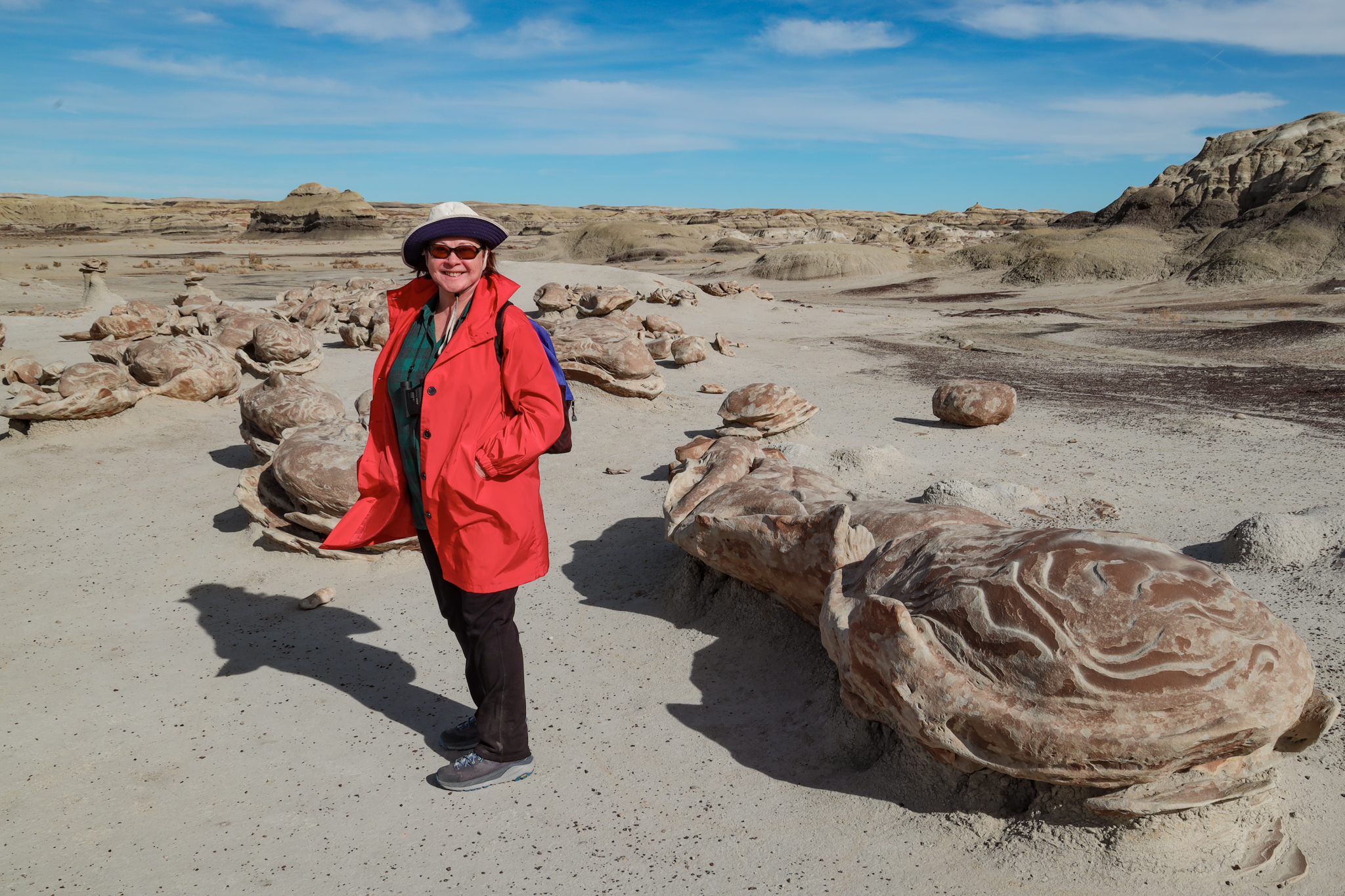
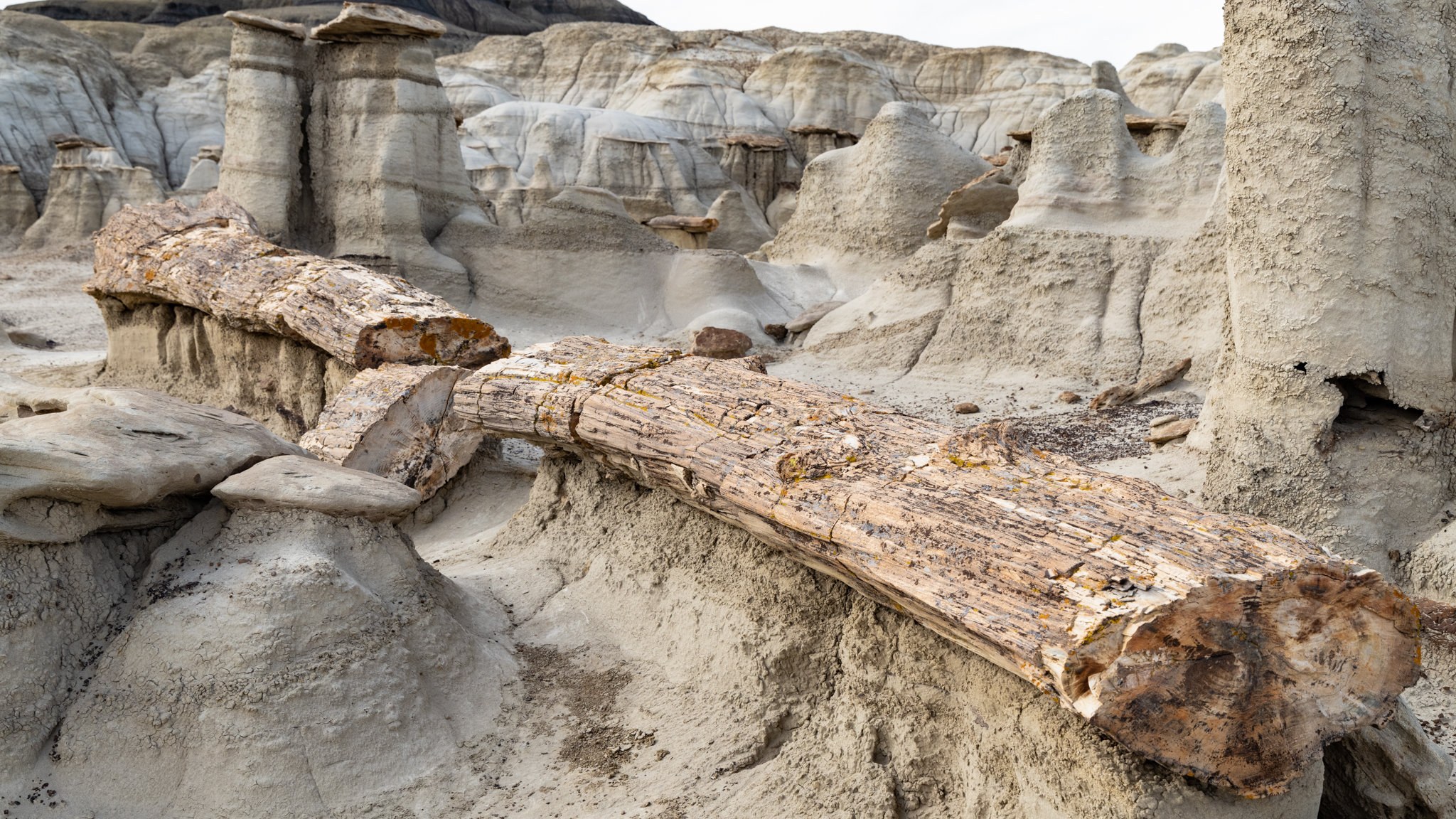
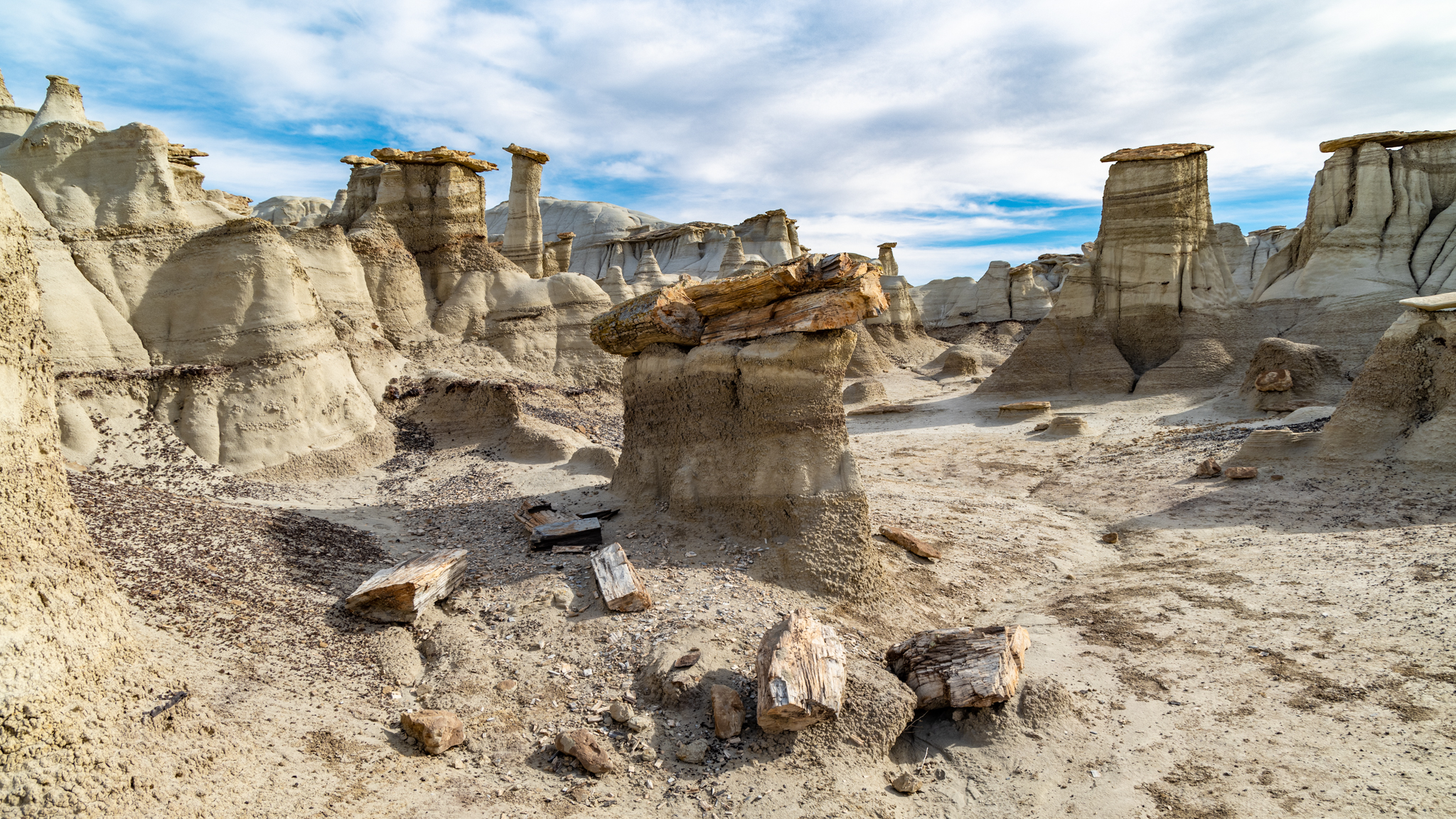
The American Southwest is an amazing, mysterious, and visually stunning place. I’ve had a fascination with it my whole life, and make excursions whenever an opportunity arises. A few years ago, Poldi and I discovered an area in New Mexico with remarkable geologic features: badlands, hoodoos, and petrified wood! It was the Bisti Wilderness Area, held apart from private and reservation land by the Bureau of Land Management for the benefit of the public. It is only very lightly “managed” by the BLM. There are no visitor centers, no picnic areas or campgrounds, and no trails. There is a small parking area at the end of a difficult dirt road, marked by a signpost and featuring an outhouse.
Despite the lack of trails, we were able to follow the breadcrumb descriptions posted online by a photographer who explores Bisti for its photogenic subjects. We located and visited the Alien Egg hatchery, a 30-foot-long petrified log, and a hoodoo village. In the years since, we have wanted to return and explore more of this fascinating area.
Poldi in the nest of alien eggsPetrified logHoodoo villagePhotos of Bisti Wilderness, November 2022. Click to expand, then scroll
We were able to do so this year. The timing was right—late Spring, before the desert becomes intolerably hot. We both researched and found several more sites with novel features bearing names like “King of Wings”, “Chocolate Penguin King”, and “Alien Throne”. These are not roadside points of interest with explanatory markers; they are deep in wilderness area, accessible to intrepid hikers willing to explore the desert and locate them. Those that are successful bring back stunning photographs.
Those photographs inspired us to consider visiting them. A particularly novel feature, “The Alien Throne”, made me wonder if I could get a picture of it with a night sky backdrop. I read the accounts of others who had made the trip. Maybe it was possible!
I still don’t have a reliable setup, but some recent changes I made to my cloud chamber have resulted in this very satisfying display of subatomic contrails. Here are a couple of recordings. The first documents when I was stunned to see multiple concurrent trails and I called for Poldi to witness it.
“Hey Poldi!” (expand to see what we were excited about).
The second video is a sustained view for several minutes, placed to background music, to mesmerize those of us who are susceptible. Think about it. This is a visual representation of the radiation that is all around us! Expand to full screen for best effect.
If you’d like to read about how I got here, the previous post describes the project of building the cloud chamber.
I had the fortune of starting my career at a signature moment in the computer revolution—the microprocessor had just been invented and it was rapidly being incorporated into the many various tools that leverage our human intelligence. Among those tools are the instruments we use to measure the world around us.
Up until then, instruments that required some amount of interaction used very direct physical interfaces: knobs, buttons, and dials for input; meters, gauges and chart recorders for output. They were wired in complex arrangements but had limitations in how complex their measurement could be.
The microprocessor changed this by providing an inexpensive logic element that could monitor and manage much more complex channels of interaction: switches, keypads, digital displays, sensors, data terminals, printers, transducers and actuators were now on the list. The opportunities to make better measurements than ever before, or measurements that simply could not be performed previously because of their complexity, now became possible. As a result, there was a renaissance in instrumentation.
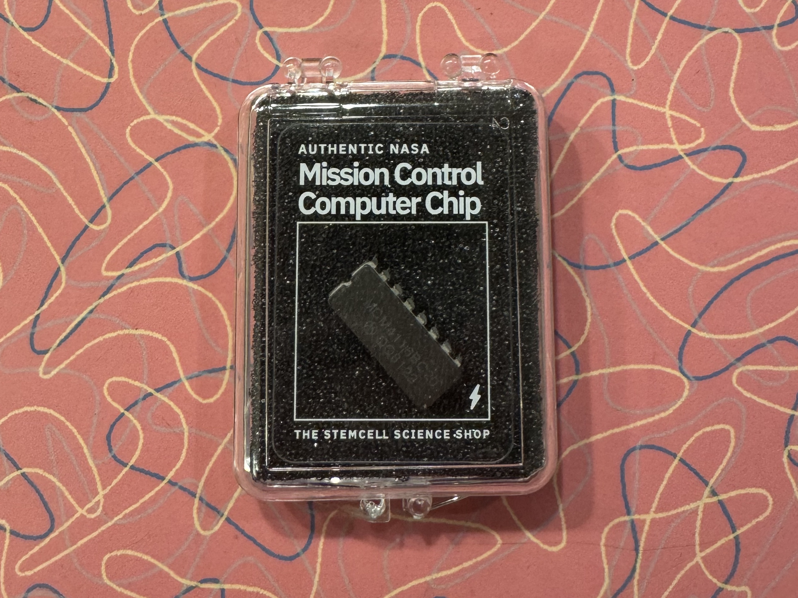
I was recently presented with a gift from a young family member. He thought I would get a kick out of a “NASA Mission Control Computer Chip.” And I did, even more than he could have imagined.
I suspect that an entrepreneur had acquired some decommissioned NASA equipment and found a way to monetize it by stripping the chips out of their sockets, packaging them, providing a backstory, and selling them to nostalgia seekers, space history nerds, and millennials looking for novel gifts for their boomer relatives. This is not a criticism. This is a fine way to keep these components from ending up in a scrap heap headed to a landfill and instead make a final tribute to a remarkable human project.
To someone born after the Apollo moon landing program, the artifacts of those times must seem just that: obsolete artifacts. There are still computer chips, of course, but they are smaller, more complex, and come in highly sophisticated packages that look nothing like those of that era. Just look inside a cell phone.
My pleasure at receiving this gift was not just the experience of once again seeing a 16-pin DIP (“dual inline package”). It was also the recalled memories of designing circuit boards with them in the 1970s. At that time, I worked for a small company that made geophysical instruments. We had employees, mostly women with fine motor skills, who hand-assembled these DIP packages, along with other electronic components onto circuit boards, soldering them into place and wiring the boards into the instrument chassis. I contributed to the design of those boards by figuring out how the digital chips needed to connect to each other.
I was curious what exact chip from mission control I had received. When I looked closely, I could see the part number stamped on its top: MCM 4116 BC20, along with the manufacturer’s logo and date code (8122- the 22nd week of 1981). This part number seemed familiar to me. I looked it up and found it to be a memory chip with 16,384 bits. Now even more memories flooded in! This was a milestone memory chip in its day!
And it was the very chip I had used in one of my first memory board designs. I was quite intimidated because it was in a class of memory called “dynamic,” which was a euphemism for memory that forgets rapidly. In order for it to not forget, it needed to be refreshed. And I had no idea how to do that.
There are now many different technologies used to store data, but in the 1970s, there were only a few, categorized by type. Read-only-memory, ROM, had data permanently etched in place. It was good for storing data that would never change, like program code and conversion tables. The other major memory type was, and is, random access memory, RAM. This is memory that can be written with any data pattern, and accessed later, in any order (randomly) to recover it. There were two types of RAM: static and dynamic. Static memory, SRAM (pronounced “ess-ram”), would retain its data state for as long as it was powered on. Dynamic memory, DRAM (“dee-ram”), as mentioned above, would fade away with time, measured in milliseconds.
Why would anyone bother with memory that didn’t remember much?
Capacity. It was possible to fit much more memory in a DRAM chip than an SRAM chip. This was due to the additional complexity (transistors) needed for the static memory cell to stay, well, static, and hold its value. In contrast, the DRAM cell comprised a single capacitor, a place to store electrons. As a result, DRAM chips had 4X the capacity of SRAM for the same size or cost.
Unfortunately, the electrons on the DRAM capacitors had the tendency to leak away. This can be compensated for by sensing the memory value before it fades, and then re-charging the capacitor to its original state. It is a lot of overhead to visit every memory cell, read it, and re-write it before time runs out, but memory was valuable, and the effort was deemed worth it.
I knew little of these underlying details of memory chips in 1977, but I did know that it was easy to design circuits using SRAM chips. Connect them up, and they seemed to “just work”. On the other hand, on hearing about the onerous demands and complexities of using DRAM, I was scared. It just seemed too complicated, and I didn’t think I knew enough to take it on. It might be really hard. So I resisted this project.
Eventually, I had to face the task. I obtained the data sheets and application notes for the DRAM chip I would be using: the 4116, just like the one recovered from mission control. In the days before the internet, this involved procuring the published data books from the parts vendor. I then dove into learning about dynamic memory and how to manage it.
I learned the basics that I described above, and I also learned that I didn’t have to read and re-write every cell. The chip could help out with that task. Memory was arranged in rows and columns of cells. If I could access each row, the chip would take care of refreshing all the columns in it! Other chips were available to invisibly help with accessing each row.
As I learned how to make the control circuits keep the memory refreshed, I realized that my fear had been unwarranted. This wasn’t so awful. It was not over my head. I knew how to do this!
I would eventually become skilled enough to use DRAM chips in high-end color displays, sometimes devoting many bytes of memory for every pixel, an unheard-of extravagance made possible with the increasing capacity and dropping costs of DRAM.
I took away a lesson from all this. Something may seem incredibly complex, like the ubiquitous example of “rocket science,” but a complex field is not necessarily a difficult field, especially to those who are in its midst and have learned along the way. As one learns a little, the next questions to ask become apparent and guide you to learn more.
As a result of this experience, I became less hesitant about taking on new and unfamiliar challenges. Confront the challenge and the results are better, and you are better.
One of the works that came out of TAT Productions in the 1960s was an educational filmstrip. “Filmstrips” were a popular and common educational resource in the days of ditto machines and library paste. They presented a sequence of images that were explained by the teacher to convey an important topic in the class.
The project was for a history assignment. I don’t remember the exact topic, but I remember being pleased that I had access to a special-purpose camera. The camera club, sponsored by our chemistry teacher, Mr Van Wyk, had equipment available to its members, including a “half-frame” camera. This enabled and inspired us (Terry and Thor, the principals of TAT Productions), to make our own filmstrip. Terry did the heavy lifting, gathering the visual sources that we would include in our filmstrip, and I provided the technical effort of operating the photographic copy stand and the lighting. We had a broad range of materials and worked to present them in a coherent explanatory sequence. I arranged the camera position, lighting, and exposure, to capture each item in its best representation. We both worked on the script to accompany the filmstrip presentation.
When we developed the film and spooled it up to load into the filmstrip projector, we discovered a “production error”. Most of the images had been taken in “portrait” aspect, taller than wide, but the filmstrip projector was designed for frames in “landscape” mode. This resulted in the class having to turn their heads to make sense of it. We soon figured out that someone could turn and hold the projector on its side while advancing the film. And some poor student had to do this whenever our history teacher inflicted our production on his subsequent classes.
TAT productions went on to undertake more projects, forgettable to most, but unforgettable to us, including “The Commercial”, “The Tell-Tale Heart”, and “Images”, all featuring fellow students and our teachers, conveying truly important messages to our classmates of those times.
Today of course, the classroom projector would automatically rotate the pictures to match their aspect. I suspect that somewhere, in the same spirit that created TAT Productions, there is a modern-day collaboration between students making TikTok videos for their history class assignment. They will probably also encounter “production problems”, but it won’t be something as simple as getting the aspect ratio wrong!
I would not stay around to see the mission end. Once the instrument was airborne, there was no further purpose for our lab in the airplane hangar, and my job title became moving man and trucker. The packing went ok, but on the way home I ran into another weather condition: severe thunderstorms. Driving the broad-sided truck east on Highway 12, it was a challenge to keep it in my lane. The rain slowed me down but fortunately, the wind was not enough to blow me over. I thought about how fickle the spring weather in the Midwest could be. After weeks of steady wind, the short window of calm that permitted a balloon launch was followed by a gale force blast, perhaps to compensate and bring the average wind speed back up to the South Dakota standard.
Our next opportunity finally arrived two weeks later. Having been through two “dress rehearsals,” we knew what to expect.
The procedure was to lay out the balloon on a protective tarp on the runway. The topmost section of the balloon, a small portion that would become the “bubble”, was fed through a retaining “spool” and folded back on itself. The top section had two tubes, made of balloon material, through which helium would be fed, inflating the bubble, which would gradually ease up from the tarp, eventually becoming large enough to lift itself off the ground entirely, with only the spool and the tension from the uninflated remainder keeping it in place.